You are here: Home > Network List > TA - USArray Transportable Network (new EarthScope stations) Stations List
> Station H56A Elgin, ON, CAN > Earthquake Result Viewer
H56A Elgin, ON, CAN - Earthquake Result Viewer
| Earthquake location: |
Near Coast Of Peru |
| Earthquake latitude/longitude: |
-15.8/-74.5 |
| Earthquake time(UTC): |
2013/09/25 (268) 16:42:43 GMT |
| Earthquake Depth: |
40 km |
| Earthquake Magnitude: |
7.1 MWW, 6.8 MI, 7.0 MWB, 7.0 MWC, 7.1 MWW, 7.1 MWC |
| Earthquake Catalog/Contributor: |
NEIC PDE/NEIC COMCAT |
|
| Network: |
TA USArray Transportable Network (new EarthScope stations) |
| Station: |
H56A Elgin, ON, CAN |
| Lat/Lon: |
44.59 N/76.26 W |
| Elevation: |
137 m |
|
| Distance: |
60.2 deg |
| Az: |
358.56 deg |
| Baz: |
178.06 deg |
| Ray Param: |
0.06163717 |
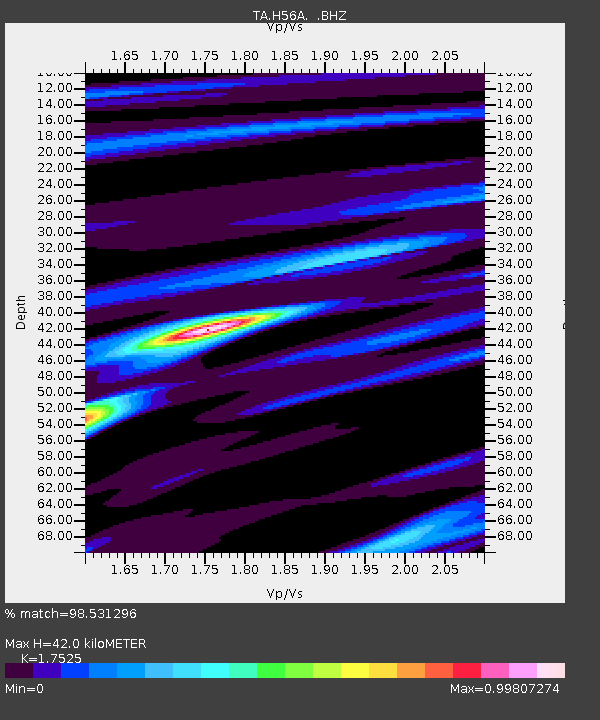
| Estimated Moho Depth: |
42.0 km |
| Estimated Crust Vp/Vs: |
1.75 |
| Assumed Crust Vp: |
6.577 km/s |
| Estimated Crust Vs: |
3.753 km/s |
| Estimated Crust Poisson's Ratio: |
0.26 |
|
| Radial Match: |
98.531296 % |
| Radial Bump: |
267 |
| Transverse Match: |
92.738525 % |
| Transverse Bump: |
400 |
| SOD ConfigId: |
626651 |
| Insert Time: |
2014-04-18 20:37:48.168 +0000 |
| GWidth: |
2.5 |
| Max Bumps: |
400 |
| Tol: |
0.001 |
|
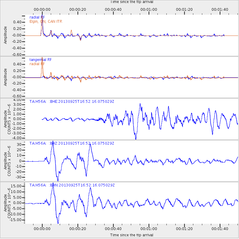
Signal To Noise
| Channel | StoN | STA | LTA |
| TA:H56A: :BHZ:20130925T16:52:16.075029Z | 26.020754 | 3.5590485E-6 | 1.367773E-7 |
| TA:H56A: :BHN:20130925T16:52:16.075029Z | 9.163734 | 1.5183086E-6 | 1.6568667E-7 |
| TA:H56A: :BHE:20130925T16:52:16.075029Z | 1.0566134 | 1.883549E-7 | 1.7826284E-7 |
| Arrivals |
| Ps | 5.1 SECOND |
| PpPs | 17 SECOND |
| PsPs/PpSs | 22 SECOND |


