You are here: Home > Network List > TA - USArray Transportable Network (new EarthScope stations) Stations List
> Station H65A Eastbrook, ME, USA > Earthquake Result Viewer
H65A Eastbrook, ME, USA - Earthquake Result Viewer
| Earthquake location: |
Near Coast Of Peru |
| Earthquake latitude/longitude: |
-15.8/-74.5 |
| Earthquake time(UTC): |
2013/09/25 (268) 16:42:43 GMT |
| Earthquake Depth: |
40 km |
| Earthquake Magnitude: |
7.1 MWW, 6.8 MI, 7.0 MWB, 7.0 MWC, 7.1 MWW, 7.1 MWC |
| Earthquake Catalog/Contributor: |
NEIC PDE/NEIC COMCAT |
|
| Network: |
TA USArray Transportable Network (new EarthScope stations) |
| Station: |
H65A Eastbrook, ME, USA |
| Lat/Lon: |
44.70 N/68.25 W |
| Elevation: |
98 m |
|
| Distance: |
60.5 deg |
| Az: |
5.129 deg |
| Baz: |
186.93 deg |
| Ray Param: |
0.061404712 |
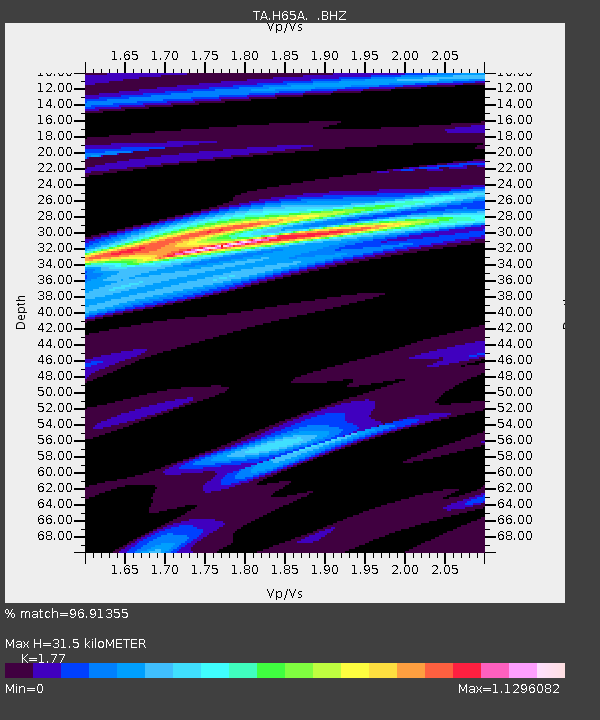
| Estimated Moho Depth: |
31.5 km |
| Estimated Crust Vp/Vs: |
1.77 |
| Assumed Crust Vp: |
6.419 km/s |
| Estimated Crust Vs: |
3.627 km/s |
| Estimated Crust Poisson's Ratio: |
0.27 |
|
| Radial Match: |
96.91355 % |
| Radial Bump: |
299 |
| Transverse Match: |
87.53368 % |
| Transverse Bump: |
400 |
| SOD ConfigId: |
626651 |
| Insert Time: |
2014-04-18 20:38:14.335 +0000 |
| GWidth: |
2.5 |
| Max Bumps: |
400 |
| Tol: |
0.001 |
|

Signal To Noise
| Channel | StoN | STA | LTA |
| TA:H65A: :BHZ:20130925T16:52:18.500017Z | 5.802462 | 2.1148899E-6 | 3.6448145E-7 |
| TA:H65A: :BHN:20130925T16:52:18.500017Z | 3.0601313 | 1.1915731E-6 | 3.893863E-7 |
| TA:H65A: :BHE:20130925T16:52:18.500017Z | 0.6947088 | 2.7867185E-7 | 4.0113474E-7 |
| Arrivals |
| Ps | 4.0 SECOND |
| PpPs | 13 SECOND |
| PsPs/PpSs | 17 SECOND |


