You are here: Home > Network List > TA - USArray Transportable Network (new EarthScope stations) Stations List
> Station I49A Point Hope, MI, USA > Earthquake Result Viewer
I49A Point Hope, MI, USA - Earthquake Result Viewer
| Earthquake location: |
Near Coast Of Peru |
| Earthquake latitude/longitude: |
-15.8/-74.5 |
| Earthquake time(UTC): |
2013/09/25 (268) 16:42:43 GMT |
| Earthquake Depth: |
40 km |
| Earthquake Magnitude: |
7.1 MWW, 6.8 MI, 7.0 MWB, 7.0 MWC, 7.1 MWW, 7.1 MWC |
| Earthquake Catalog/Contributor: |
NEIC PDE/NEIC COMCAT |
|
| Network: |
TA USArray Transportable Network (new EarthScope stations) |
| Station: |
I49A Point Hope, MI, USA |
| Lat/Lon: |
43.94 N/82.82 W |
| Elevation: |
217 m |
|
| Distance: |
60.0 deg |
| Az: |
353.071 deg |
| Baz: |
170.75 deg |
| Ray Param: |
0.06176104 |
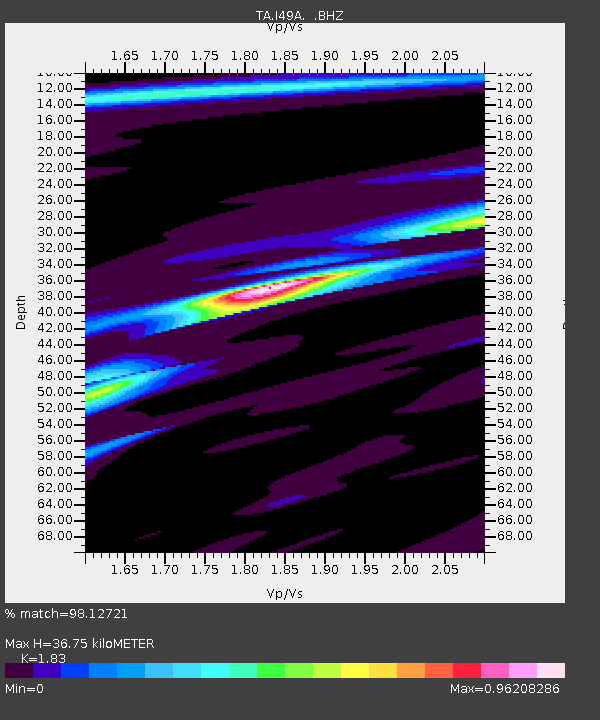
| Estimated Moho Depth: |
36.75 km |
| Estimated Crust Vp/Vs: |
1.83 |
| Assumed Crust Vp: |
6.483 km/s |
| Estimated Crust Vs: |
3.542 km/s |
| Estimated Crust Poisson's Ratio: |
0.29 |
|
| Radial Match: |
98.12721 % |
| Radial Bump: |
215 |
| Transverse Match: |
89.70871 % |
| Transverse Bump: |
384 |
| SOD ConfigId: |
626651 |
| Insert Time: |
2014-04-18 20:38:49.805 +0000 |
| GWidth: |
2.5 |
| Max Bumps: |
400 |
| Tol: |
0.001 |
|

Signal To Noise
| Channel | StoN | STA | LTA |
| TA:I49A: :BHZ:20130925T16:52:14.77498Z | 27.967876 | 1.2625954E-5 | 4.5144486E-7 |
| TA:I49A: :BHN:20130925T16:52:14.77498Z | 18.170542 | 6.029534E-6 | 3.3183017E-7 |
| TA:I49A: :BHE:20130925T16:52:14.77498Z | 1.8311589 | 7.830035E-7 | 4.2759996E-7 |
| Arrivals |
| Ps | 4.9 SECOND |
| PpPs | 15 SECOND |
| PsPs/PpSs | 20 SECOND |


