You are here: Home > Network List > TA - USArray Transportable Network (new EarthScope stations) Stations List
> Station I52A Shelburne, ON, CAN > Earthquake Result Viewer
I52A Shelburne, ON, CAN - Earthquake Result Viewer
| Earthquake location: |
Near Coast Of Peru |
| Earthquake latitude/longitude: |
-15.8/-74.5 |
| Earthquake time(UTC): |
2013/09/25 (268) 16:42:43 GMT |
| Earthquake Depth: |
40 km |
| Earthquake Magnitude: |
7.1 MWW, 6.8 MI, 7.0 MWB, 7.0 MWC, 7.1 MWW, 7.1 MWC |
| Earthquake Catalog/Contributor: |
NEIC PDE/NEIC COMCAT |
|
| Network: |
TA USArray Transportable Network (new EarthScope stations) |
| Station: |
I52A Shelburne, ON, CAN |
| Lat/Lon: |
44.07 N/80.18 W |
| Elevation: |
505 m |
|
| Distance: |
59.8 deg |
| Az: |
355.279 deg |
| Baz: |
173.69 deg |
| Ray Param: |
0.061846934 |
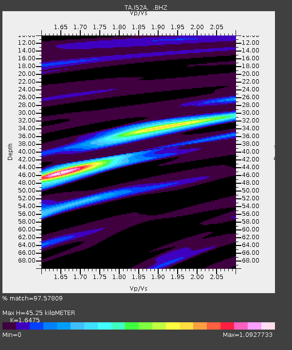
| Estimated Moho Depth: |
45.25 km |
| Estimated Crust Vp/Vs: |
1.65 |
| Assumed Crust Vp: |
6.53 km/s |
| Estimated Crust Vs: |
3.964 km/s |
| Estimated Crust Poisson's Ratio: |
0.21 |
|
| Radial Match: |
97.57809 % |
| Radial Bump: |
262 |
| Transverse Match: |
89.50952 % |
| Transverse Bump: |
400 |
| SOD ConfigId: |
626651 |
| Insert Time: |
2014-04-18 20:38:53.036 +0000 |
| GWidth: |
2.5 |
| Max Bumps: |
400 |
| Tol: |
0.001 |
|

Signal To Noise
| Channel | StoN | STA | LTA |
| TA:I52A: :BHZ:20130925T16:52:13.875017Z | 10.85529 | 8.511861E-6 | 7.8412097E-7 |
| TA:I52A: :BHN:20130925T16:52:13.875017Z | 10.755397 | 3.988118E-6 | 3.7080156E-7 |
| TA:I52A: :BHE:20130925T16:52:13.875017Z | 1.7891166 | 6.3768044E-7 | 3.5642196E-7 |
| Arrivals |
| Ps | 4.7 SECOND |
| PpPs | 17 SECOND |
| PsPs/PpSs | 22 SECOND |


