You are here: Home > Network List > YB13 - Continental Dynamics/Cent. Anatolian Tectonics:Surface to Mantle Dynamics During Stations List
> Station AT09 Yukariulupinar,Malatya,Turkey > Earthquake Result Viewer
AT09 Yukariulupinar,Malatya,Turkey - Earthquake Result Viewer
| Earthquake location: |
Northern Molucca Sea |
| Earthquake latitude/longitude: |
1.9/126.5 |
| Earthquake time(UTC): |
2014/11/26 (330) 14:33:43 GMT |
| Earthquake Depth: |
39 km |
| Earthquake Magnitude: |
6.8 MWW, 6.8 MWC, 6.8 MWB, 7.0 MI |
| Earthquake Catalog/Contributor: |
NEIC PDE/NEIC COMCAT |
|
| Network: |
YB Continental Dynamics/Cent. Anatolian Tectonics:Surface to Mantle Dynamics During |
| Station: |
AT09 Yukariulupinar,Malatya,Turkey |
| Lat/Lon: |
38.40 N/37.57 E |
| Elevation: |
1429 m |
|
| Distance: |
88.0 deg |
| Az: |
308.182 deg |
| Baz: |
89.141 deg |
| Ray Param: |
0.042854 |
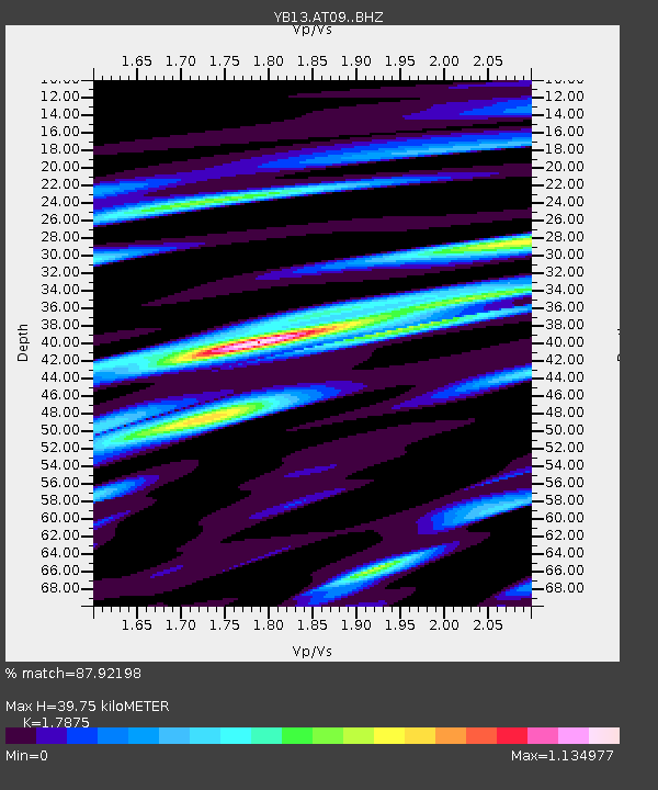
| Estimated Moho Depth: |
39.75 km |
| Estimated Crust Vp/Vs: |
1.79 |
| Assumed Crust Vp: |
6.35 km/s |
| Estimated Crust Vs: |
3.552 km/s |
| Estimated Crust Poisson's Ratio: |
0.27 |
|
| Radial Match: |
87.92198 % |
| Radial Bump: |
400 |
| Transverse Match: |
76.50124 % |
| Transverse Bump: |
400 |
| SOD ConfigId: |
3390531 |
| Insert Time: |
2019-04-15 05:00:48.227 +0000 |
| GWidth: |
2.5 |
| Max Bumps: |
400 |
| Tol: |
0.001 |
|

Signal To Noise
| Channel | StoN | STA | LTA |
| YB:AT09: :BHZ:20141126T14:45:58.62001Z | 13.443 | 9.275962E-7 | 6.900217E-8 |
| YB:AT09: :BHN:20141126T14:45:58.62001Z | 1.6186407 | 1.2664889E-7 | 7.824398E-8 |
| YB:AT09: :BHE:20141126T14:45:58.62001Z | 1.2192259 | 1.2001549E-7 | 9.8435805E-8 |
| Arrivals |
| Ps | 5.0 SECOND |
| PpPs | 17 SECOND |
| PsPs/PpSs | 22 SECOND |


