You are here: Home > Network List > TA - USArray Transportable Network (new EarthScope stations) Stations List
> Station J45A Montague, MI, USA > Earthquake Result Viewer
J45A Montague, MI, USA - Earthquake Result Viewer
| Earthquake location: |
Near Coast Of Peru |
| Earthquake latitude/longitude: |
-15.8/-74.5 |
| Earthquake time(UTC): |
2013/09/25 (268) 16:42:43 GMT |
| Earthquake Depth: |
40 km |
| Earthquake Magnitude: |
7.1 MWW, 6.8 MI, 7.0 MWB, 7.0 MWC, 7.1 MWW, 7.1 MWC |
| Earthquake Catalog/Contributor: |
NEIC PDE/NEIC COMCAT |
|
| Network: |
TA USArray Transportable Network (new EarthScope stations) |
| Station: |
J45A Montague, MI, USA |
| Lat/Lon: |
43.44 N/86.39 W |
| Elevation: |
209 m |
|
| Distance: |
60.0 deg |
| Az: |
350.028 deg |
| Baz: |
166.773 deg |
| Ray Param: |
0.061754968 |
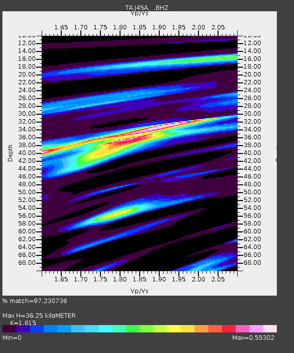
| Estimated Moho Depth: |
36.25 km |
| Estimated Crust Vp/Vs: |
1.82 |
| Assumed Crust Vp: |
6.483 km/s |
| Estimated Crust Vs: |
3.572 km/s |
| Estimated Crust Poisson's Ratio: |
0.28 |
|
| Radial Match: |
97.230736 % |
| Radial Bump: |
307 |
| Transverse Match: |
84.37335 % |
| Transverse Bump: |
400 |
| SOD ConfigId: |
626651 |
| Insert Time: |
2014-04-18 20:39:25.883 +0000 |
| GWidth: |
2.5 |
| Max Bumps: |
400 |
| Tol: |
0.001 |
|
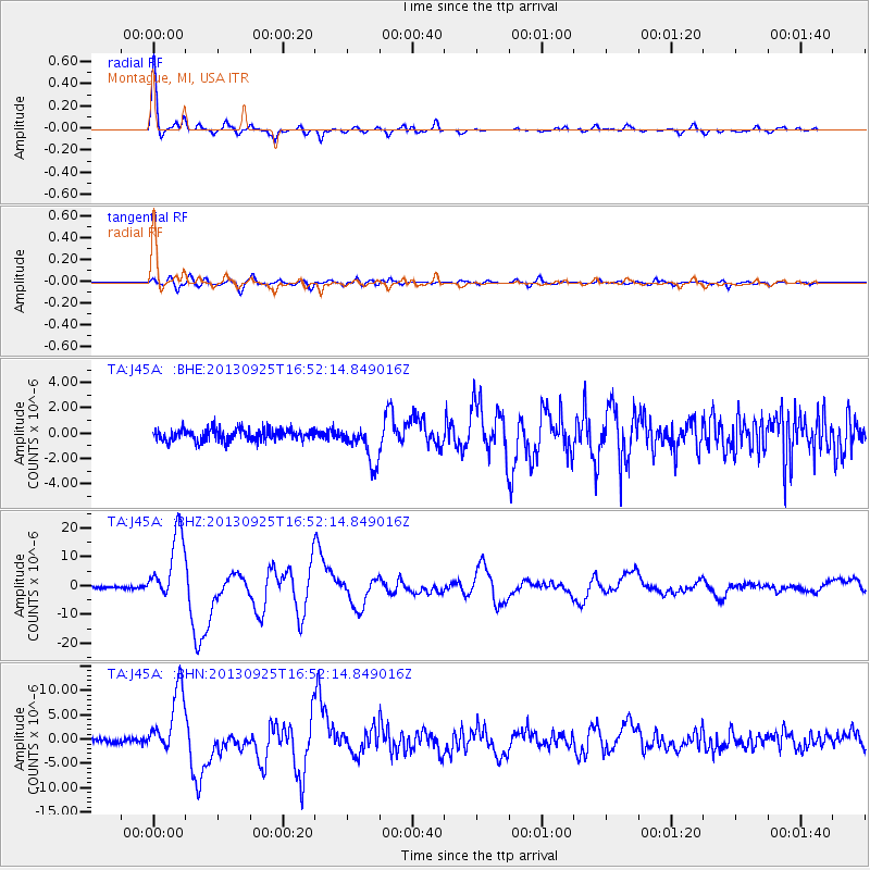
Signal To Noise
| Channel | StoN | STA | LTA |
| TA:J45A: :BHZ:20130925T16:52:14.849016Z | 33.00671 | 1.2036459E-5 | 3.6466702E-7 |
| TA:J45A: :BHN:20130925T16:52:14.849016Z | 17.807304 | 6.757671E-6 | 3.794887E-7 |
| TA:J45A: :BHE:20130925T16:52:14.849016Z | 3.1598141 | 1.5061363E-6 | 4.7665347E-7 |
| Arrivals |
| Ps | 4.8 SECOND |
| PpPs | 15 SECOND |
| PsPs/PpSs | 20 SECOND |


