You are here: Home > Network List > YB13 - Continental Dynamics/Cent. Anatolian Tectonics:Surface to Mantle Dynamics During Stations List
> Station AT28 Suleymanobasi,Gaziantep,Turkey > Earthquake Result Viewer
AT28 Suleymanobasi,Gaziantep,Turkey - Earthquake Result Viewer
| Earthquake location: |
Northern Molucca Sea |
| Earthquake latitude/longitude: |
1.9/126.5 |
| Earthquake time(UTC): |
2014/11/26 (330) 14:33:43 GMT |
| Earthquake Depth: |
39 km |
| Earthquake Magnitude: |
6.8 MWW, 6.8 MWC, 6.8 MWB, 7.0 MI |
| Earthquake Catalog/Contributor: |
NEIC PDE/NEIC COMCAT |
|
| Network: |
YB Continental Dynamics/Cent. Anatolian Tectonics:Surface to Mantle Dynamics During |
| Station: |
AT28 Suleymanobasi,Gaziantep,Turkey |
| Lat/Lon: |
37.25 N/37.55 E |
| Elevation: |
839 m |
|
| Distance: |
88.0 deg |
| Az: |
307.035 deg |
| Baz: |
89.09 deg |
| Ray Param: |
0.042829394 |
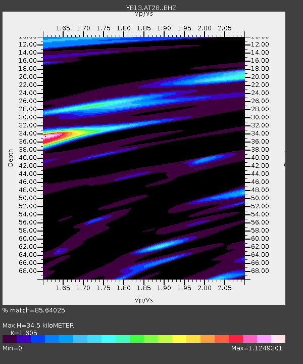
| Estimated Moho Depth: |
34.5 km |
| Estimated Crust Vp/Vs: |
1.61 |
| Assumed Crust Vp: |
6.247 km/s |
| Estimated Crust Vs: |
3.892 km/s |
| Estimated Crust Poisson's Ratio: |
0.18 |
|
| Radial Match: |
85.64025 % |
| Radial Bump: |
400 |
| Transverse Match: |
73.489044 % |
| Transverse Bump: |
400 |
| SOD ConfigId: |
3390531 |
| Insert Time: |
2019-04-15 05:00:58.748 +0000 |
| GWidth: |
2.5 |
| Max Bumps: |
400 |
| Tol: |
0.001 |
|

Signal To Noise
| Channel | StoN | STA | LTA |
| YB:AT28: :BHZ:20141126T14:45:58.779983Z | 10.677981 | 1.7188804E-6 | 1.6097428E-7 |
| YB:AT28: :BHN:20141126T14:45:58.779983Z | 0.9236461 | 1.3621843E-7 | 1.4747903E-7 |
| YB:AT28: :BHE:20141126T14:45:58.779983Z | 2.716937 | 3.909006E-7 | 1.4387547E-7 |
| Arrivals |
| Ps | 3.4 SECOND |
| PpPs | 14 SECOND |
| PsPs/PpSs | 17 SECOND |


