You are here: Home > Network List > TA - USArray Transportable Network (new EarthScope stations) Stations List
> Station J48A Bridge Port, MI, USA > Earthquake Result Viewer
J48A Bridge Port, MI, USA - Earthquake Result Viewer
| Earthquake location: |
Near Coast Of Peru |
| Earthquake latitude/longitude: |
-15.8/-74.5 |
| Earthquake time(UTC): |
2013/09/25 (268) 16:42:43 GMT |
| Earthquake Depth: |
40 km |
| Earthquake Magnitude: |
7.1 MWW, 6.8 MI, 7.0 MWB, 7.0 MWC, 7.1 MWW, 7.1 MWC |
| Earthquake Catalog/Contributor: |
NEIC PDE/NEIC COMCAT |
|
| Network: |
TA USArray Transportable Network (new EarthScope stations) |
| Station: |
J48A Bridge Port, MI, USA |
| Lat/Lon: |
43.30 N/82.78 W |
| Elevation: |
195 m |
|
| Distance: |
59.3 deg |
| Az: |
352.984 deg |
| Baz: |
170.733 deg |
| Ray Param: |
0.062177733 |
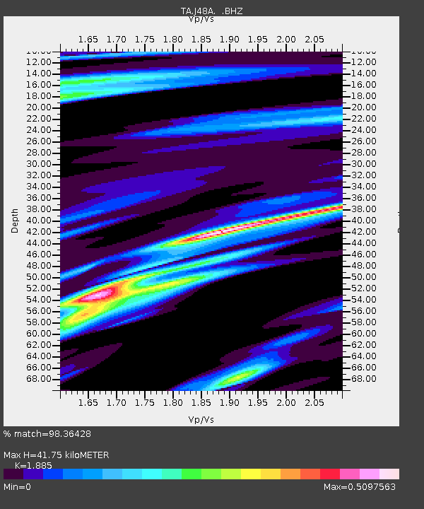
| Estimated Moho Depth: |
41.75 km |
| Estimated Crust Vp/Vs: |
1.88 |
| Assumed Crust Vp: |
6.483 km/s |
| Estimated Crust Vs: |
3.439 km/s |
| Estimated Crust Poisson's Ratio: |
0.30 |
|
| Radial Match: |
98.36428 % |
| Radial Bump: |
222 |
| Transverse Match: |
94.72726 % |
| Transverse Bump: |
400 |
| SOD ConfigId: |
626651 |
| Insert Time: |
2014-04-18 20:39:35.803 +0000 |
| GWidth: |
2.5 |
| Max Bumps: |
400 |
| Tol: |
0.001 |
|

Signal To Noise
| Channel | StoN | STA | LTA |
| TA:J48A: :BHZ:20130925T16:52:11.27498Z | 41.82159 | 9.19672E-6 | 2.1990365E-7 |
| TA:J48A: :BHN:20130925T16:52:11.27498Z | 18.372892 | 3.406494E-6 | 1.854087E-7 |
| TA:J48A: :BHE:20130925T16:52:11.27498Z | 5.228557 | 1.0970077E-6 | 2.0981079E-7 |
| Arrivals |
| Ps | 6.0 SECOND |
| PpPs | 18 SECOND |
| PsPs/PpSs | 24 SECOND |


