You are here: Home > Network List > TA - USArray Transportable Network (new EarthScope stations) Stations List
> Station J62A Henniker, NH, USA > Earthquake Result Viewer
J62A Henniker, NH, USA - Earthquake Result Viewer
| Earthquake location: |
Near Coast Of Peru |
| Earthquake latitude/longitude: |
-15.8/-74.5 |
| Earthquake time(UTC): |
2013/09/25 (268) 16:42:43 GMT |
| Earthquake Depth: |
40 km |
| Earthquake Magnitude: |
7.1 MWW, 6.8 MI, 7.0 MWB, 7.0 MWC, 7.1 MWW, 7.1 MWC |
| Earthquake Catalog/Contributor: |
NEIC PDE/NEIC COMCAT |
|
| Network: |
TA USArray Transportable Network (new EarthScope stations) |
| Station: |
J62A Henniker, NH, USA |
| Lat/Lon: |
43.23 N/71.81 W |
| Elevation: |
266 m |
|
| Distance: |
58.8 deg |
| Az: |
2.305 deg |
| Baz: |
183.036 deg |
| Ray Param: |
0.062513 |
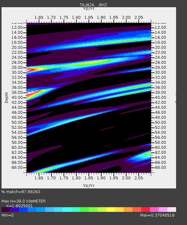
| Estimated Moho Depth: |
38.0 km |
| Estimated Crust Vp/Vs: |
1.60 |
| Assumed Crust Vp: |
6.419 km/s |
| Estimated Crust Vs: |
4.006 km/s |
| Estimated Crust Poisson's Ratio: |
0.18 |
|
| Radial Match: |
97.98263 % |
| Radial Bump: |
229 |
| Transverse Match: |
92.48835 % |
| Transverse Bump: |
400 |
| SOD ConfigId: |
626651 |
| Insert Time: |
2014-04-18 20:39:58.814 +0000 |
| GWidth: |
2.5 |
| Max Bumps: |
400 |
| Tol: |
0.001 |
|
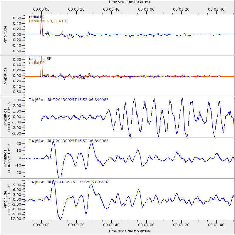
Signal To Noise
| Channel | StoN | STA | LTA |
| TA:J62A: :BHZ:20130925T16:52:06.89998Z | 5.597062 | 1.9963911E-6 | 3.5668555E-7 |
| TA:J62A: :BHN:20130925T16:52:06.89998Z | 4.0794926 | 1.0224408E-6 | 2.506294E-7 |
| TA:J62A: :BHE:20130925T16:52:06.89998Z | 0.90235865 | 1.8783805E-7 | 2.0816341E-7 |
| Arrivals |
| Ps | 3.8 SECOND |
| PpPs | 15 SECOND |
| PsPs/PpSs | 18 SECOND |


