You are here: Home > Network List > TA - USArray Transportable Network (new EarthScope stations) Stations List
> Station K57A Scipio Center, NY, USA > Earthquake Result Viewer
K57A Scipio Center, NY, USA - Earthquake Result Viewer
| Earthquake location: |
Near Coast Of Peru |
| Earthquake latitude/longitude: |
-15.8/-74.5 |
| Earthquake time(UTC): |
2013/09/25 (268) 16:42:43 GMT |
| Earthquake Depth: |
40 km |
| Earthquake Magnitude: |
7.1 MWW, 6.8 MI, 7.0 MWB, 7.0 MWC, 7.1 MWW, 7.1 MWC |
| Earthquake Catalog/Contributor: |
NEIC PDE/NEIC COMCAT |
|
| Network: |
TA USArray Transportable Network (new EarthScope stations) |
| Station: |
K57A Scipio Center, NY, USA |
| Lat/Lon: |
42.73 N/76.52 W |
| Elevation: |
408 m |
|
| Distance: |
58.3 deg |
| Az: |
358.264 deg |
| Baz: |
177.732 deg |
| Ray Param: |
0.062849954 |
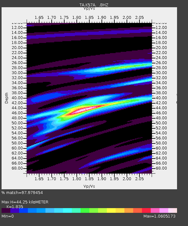
| Estimated Moho Depth: |
44.25 km |
| Estimated Crust Vp/Vs: |
1.84 |
| Assumed Crust Vp: |
6.476 km/s |
| Estimated Crust Vs: |
3.529 km/s |
| Estimated Crust Poisson's Ratio: |
0.29 |
|
| Radial Match: |
97.979454 % |
| Radial Bump: |
217 |
| Transverse Match: |
90.90864 % |
| Transverse Bump: |
400 |
| SOD ConfigId: |
626651 |
| Insert Time: |
2014-04-18 20:40:35.962 +0000 |
| GWidth: |
2.5 |
| Max Bumps: |
400 |
| Tol: |
0.001 |
|
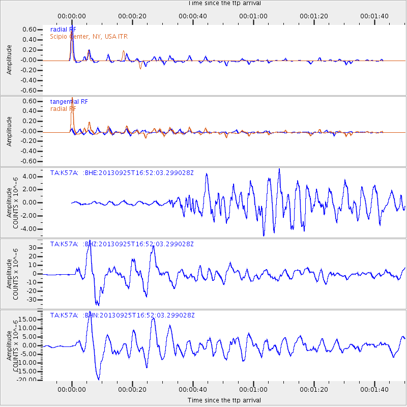
Signal To Noise
| Channel | StoN | STA | LTA |
| TA:K57A: :BHZ:20130925T16:52:03.299028Z | 18.886562 | 4.63033E-6 | 2.4516532E-7 |
| TA:K57A: :BHN:20130925T16:52:03.299028Z | 6.46142 | 1.9280228E-6 | 2.9838995E-7 |
| TA:K57A: :BHE:20130925T16:52:03.299028Z | 1.4596382 | 2.6420747E-7 | 1.8100887E-7 |
| Arrivals |
| Ps | 6.0 SECOND |
| PpPs | 18 SECOND |
| PsPs/PpSs | 24 SECOND |


