You are here: Home > Network List > TA - USArray Transportable Network (new EarthScope stations) Stations List
> Station K60A Five Rivers Env. Education Center, Delmar, NY, USA > Earthquake Result Viewer
K60A Five Rivers Env. Education Center, Delmar, NY, USA - Earthquake Result Viewer

| Earthquake location: |
Near Coast Of Peru |
| Earthquake latitude/longitude: |
-15.8/-74.5 |
| Earthquake time(UTC): |
2013/09/25 (268) 16:42:43 GMT |
| Earthquake Depth: |
40 km |
| Earthquake Magnitude: |
7.1 MWW, 6.8 MI, 7.0 MWB, 7.0 MWC, 7.1 MWW, 7.1 MWC |
| Earthquake Catalog/Contributor: |
NEIC PDE/NEIC COMCAT |
|
| Network: |
TA USArray Transportable Network (new EarthScope stations) |
| Station: |
K60A Five Rivers Env. Education Center, Delmar, NY, USA |
| Lat/Lon: |
42.62 N/73.89 W |
| Elevation: |
79 m |
|
| Distance: |
58.2 deg |
| Az: |
0.541 deg |
| Baz: |
180.705 deg |
| Ray Param: |
0.06294163 |
| Estimated Moho Depth: |
38.75 km |
| Estimated Crust Vp/Vs: |
1.89 |
| Assumed Crust Vp: |
6.419 km/s |
| Estimated Crust Vs: |
3.401 km/s |
| Estimated Crust Poisson's Ratio: |
0.30 |
|
| Radial Match: |
98.53875 % |
| Radial Bump: |
193 |
| Transverse Match: |
90.27927 % |
| Transverse Bump: |
400 |
| SOD ConfigId: |
626651 |
| Insert Time: |
2014-04-18 20:40:43.339 +0000 |
| GWidth: |
2.5 |
| Max Bumps: |
400 |
| Tol: |
0.001 |
|
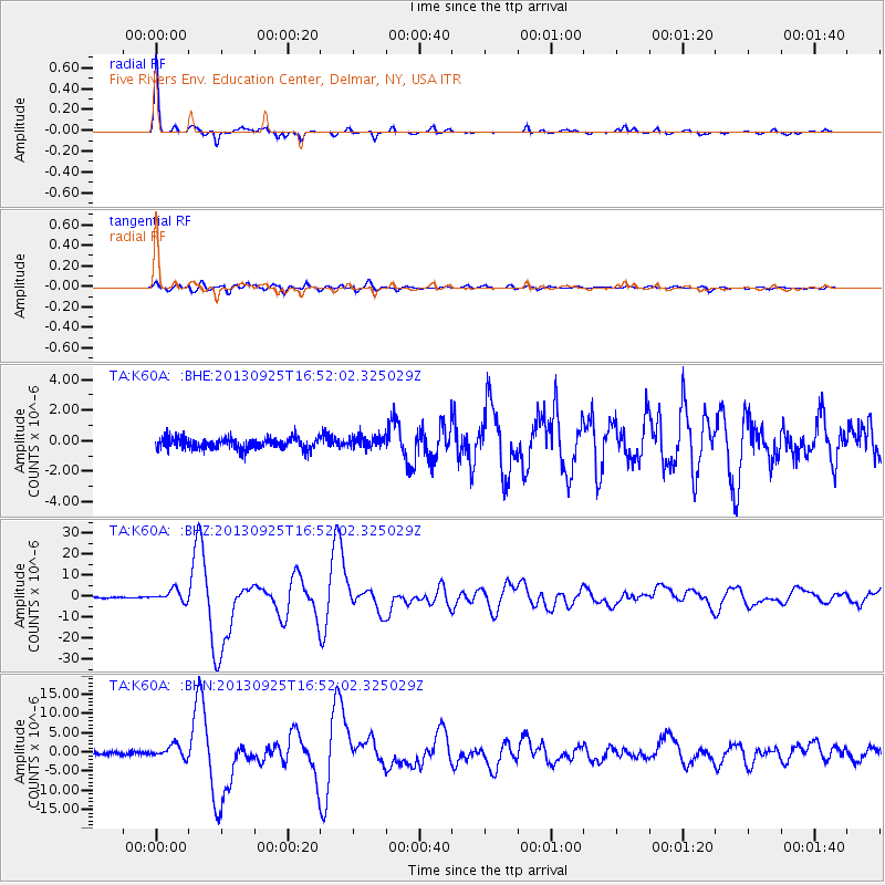
Signal To Noise
| Channel | StoN | STA | LTA |
| TA:K60A: :BHZ:20130925T16:52:02.325029Z | 10.567659 | 2.7788144E-6 | 2.6295456E-7 |
| TA:K60A: :BHN:20130925T16:52:02.325029Z | 4.4047017 | 1.6404567E-6 | 3.724331E-7 |
| TA:K60A: :BHE:20130925T16:52:02.325029Z | 1.0352309 | 3.8770594E-7 | 3.7451156E-7 |
| Arrivals |
| Ps | 5.6 SECOND |
| PpPs | 17 SECOND |
| PsPs/PpSs | 22 SECOND |


