You are here: Home > Network List > TA - USArray Transportable Network (new EarthScope stations) Stations List
> Station L57A Andrews Acres Farm, Gillet, PA, USA > Earthquake Result Viewer
L57A Andrews Acres Farm, Gillet, PA, USA - Earthquake Result Viewer
| Earthquake location: |
Near Coast Of Peru |
| Earthquake latitude/longitude: |
-15.8/-74.5 |
| Earthquake time(UTC): |
2013/09/25 (268) 16:42:43 GMT |
| Earthquake Depth: |
40 km |
| Earthquake Magnitude: |
7.1 MWW, 6.8 MI, 7.0 MWB, 7.0 MWC, 7.1 MWW, 7.1 MWC |
| Earthquake Catalog/Contributor: |
NEIC PDE/NEIC COMCAT |
|
| Network: |
TA USArray Transportable Network (new EarthScope stations) |
| Station: |
L57A Andrews Acres Farm, Gillet, PA, USA |
| Lat/Lon: |
42.00 N/76.85 W |
| Elevation: |
546 m |
|
| Distance: |
57.6 deg |
| Az: |
357.936 deg |
| Baz: |
177.334 deg |
| Ray Param: |
0.06331642 |
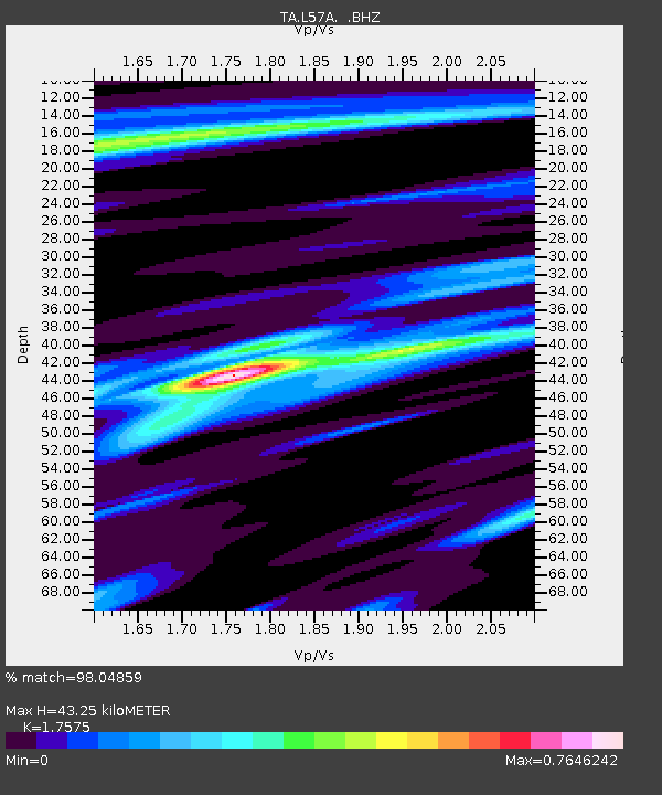
| Estimated Moho Depth: |
43.25 km |
| Estimated Crust Vp/Vs: |
1.76 |
| Assumed Crust Vp: |
6.476 km/s |
| Estimated Crust Vs: |
3.685 km/s |
| Estimated Crust Poisson's Ratio: |
0.26 |
|
| Radial Match: |
98.04859 % |
| Radial Bump: |
267 |
| Transverse Match: |
93.00607 % |
| Transverse Bump: |
400 |
| SOD ConfigId: |
626651 |
| Insert Time: |
2014-04-18 20:41:31.015 +0000 |
| GWidth: |
2.5 |
| Max Bumps: |
400 |
| Tol: |
0.001 |
|
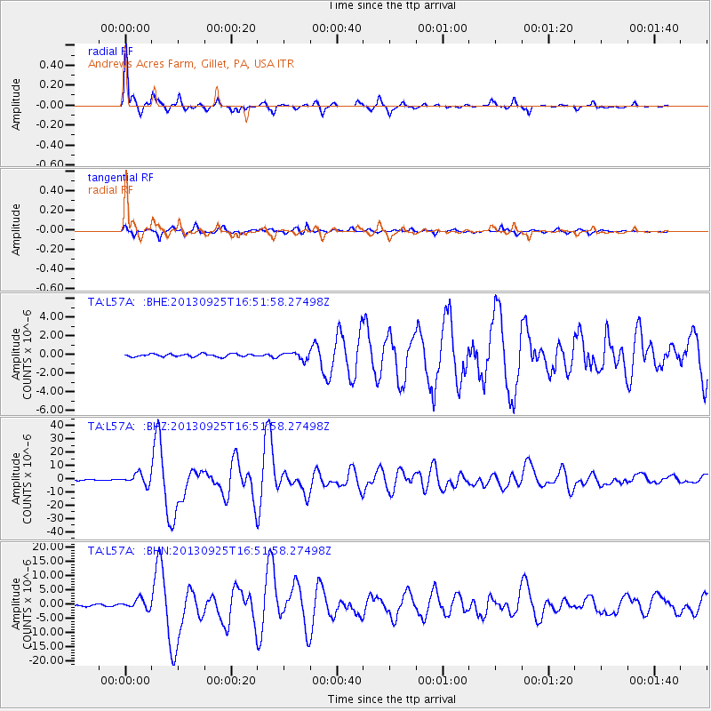
Signal To Noise
| Channel | StoN | STA | LTA |
| TA:L57A: :BHZ:20130925T16:51:58.27498Z | 15.205267 | 4.0858617E-6 | 2.687136E-7 |
| TA:L57A: :BHN:20130925T16:51:58.27498Z | 7.69693 | 1.7103749E-6 | 2.222152E-7 |
| TA:L57A: :BHE:20130925T16:51:58.27498Z | 2.4866195 | 3.6268352E-7 | 1.4585406E-7 |
| Arrivals |
| Ps | 5.3 SECOND |
| PpPs | 18 SECOND |
| PsPs/PpSs | 23 SECOND |


