You are here: Home > Network List > YQ13 - Study of Extension and Magmatism in Malawi and Tanzania Stations List
> Station THAN Thanula,Malawi > Earthquake Result Viewer
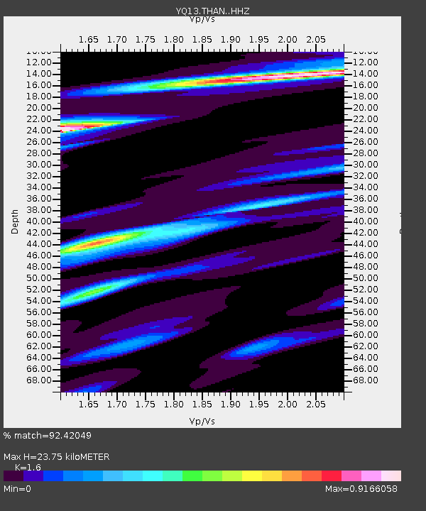
THAN Thanula,Malawi - Earthquake Result Viewer
| Earthquake location: |
Northern Molucca Sea |
| Earthquake latitude/longitude: |
1.9/126.5 |
| Earthquake time(UTC): |
2014/11/26 (330) 14:33:43 GMT |
| Earthquake Depth: |
39 km |
| Earthquake Magnitude: |
6.8 MWW, 6.8 MWC, 6.8 MWB, 7.0 MI |
| Earthquake Catalog/Contributor: |
NEIC PDE/NEIC COMCAT |
|
| Network: |
YQ Study of Extension and Magmatism in Malawi and Tanzania |
| Station: |
THAN Thanula,Malawi |
| Lat/Lon: |
11.47 S/34.18 E |
| Elevation: |
683 m |
|
| Distance: |
92.7 deg |
| Az: |
258.679 deg |
| Baz: |
88.589 deg |
| Ray Param: |
0.041396875 |
| Estimated Moho Depth: |
23.75 km |
| Estimated Crust Vp/Vs: |
1.60 |
| Assumed Crust Vp: |
6.502 km/s |
| Estimated Crust Vs: |
4.063 km/s |
| Estimated Crust Poisson's Ratio: |
0.18 |
|
| Radial Match: |
92.42049 % |
| Radial Bump: |
370 |
| Transverse Match: |
80.04803 % |
| Transverse Bump: |
400 |
| SOD ConfigId: |
3390531 |
| Insert Time: |
2019-04-15 05:01:41.413 +0000 |
| GWidth: |
2.5 |
| Max Bumps: |
400 |
| Tol: |
0.001 |
|

Signal To Noise
| Channel | StoN | STA | LTA |
| YQ:THAN: :HHZ:20141126T14:46:20.430007Z | 19.760294 | 7.1267215E-7 | 3.6065867E-8 |
| YQ:THAN: :HHN:20141126T14:46:20.430007Z | 1.2162558 | 9.886976E-8 | 8.129027E-8 |
| YQ:THAN: :HHE:20141126T14:46:20.430007Z | 4.104129 | 3.0529333E-7 | 7.4386875E-8 |
| Arrivals |
| Ps | 2.2 SECOND |
| PpPs | 9.3 SECOND |
| PsPs/PpSs | 12 SECOND |


