You are here: Home > Network List > TA - USArray Transportable Network (new EarthScope stations) Stations List
> Station M57A Sunshine Farm, Cogan Station, PA, USA > Earthquake Result Viewer
M57A Sunshine Farm, Cogan Station, PA, USA - Earthquake Result Viewer
| Earthquake location: |
Near Coast Of Peru |
| Earthquake latitude/longitude: |
-15.8/-74.5 |
| Earthquake time(UTC): |
2013/09/25 (268) 16:42:43 GMT |
| Earthquake Depth: |
40 km |
| Earthquake Magnitude: |
7.1 MWW, 6.8 MI, 7.0 MWB, 7.0 MWC, 7.1 MWW, 7.1 MWC |
| Earthquake Catalog/Contributor: |
NEIC PDE/NEIC COMCAT |
|
| Network: |
TA USArray Transportable Network (new EarthScope stations) |
| Station: |
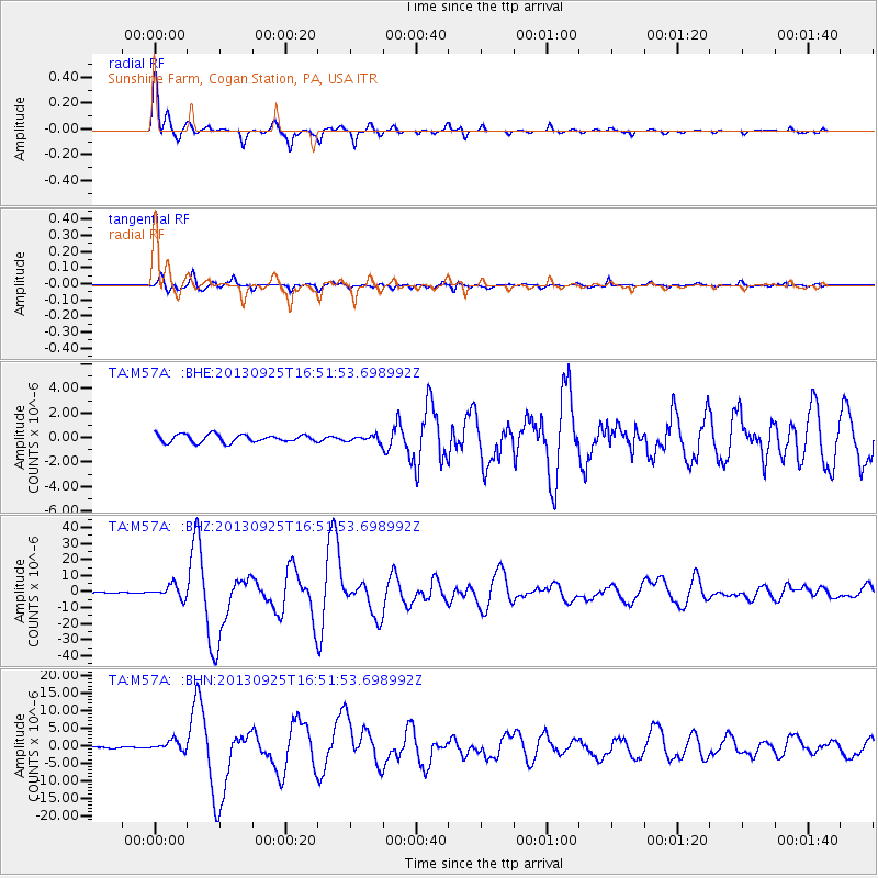
M57A Sunshine Farm, Cogan Station, PA, USA |
| Lat/Lon: |
41.34 N/77.13 W |
| Elevation: |
319 m |
|
| Distance: |
56.9 deg |
| Az: |
357.649 deg |
| Baz: |
176.994 deg |
| Ray Param: |
0.06373328 |
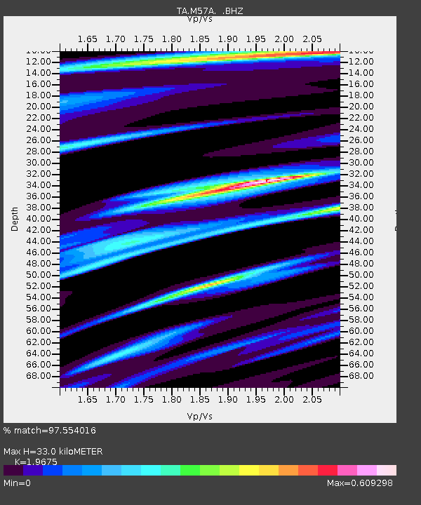
| Estimated Moho Depth: |
33.0 km |
| Estimated Crust Vp/Vs: |
1.97 |
| Assumed Crust Vp: |
6.121 km/s |
| Estimated Crust Vs: |
3.111 km/s |
| Estimated Crust Poisson's Ratio: |
0.33 |
|
| Radial Match: |
97.554016 % |
| Radial Bump: |
285 |
| Transverse Match: |
94.161446 % |
| Transverse Bump: |
400 |
| SOD ConfigId: |
626651 |
| Insert Time: |
2014-04-18 20:42:20.184 +0000 |
| GWidth: |
2.5 |
| Max Bumps: |
400 |
| Tol: |
0.001 |
|
Signal To Noise
| Channel | StoN | STA | LTA |
| TA:M57A: :BHZ:20130925T16:51:53.698992Z | 7.507529 | 3.999872E-6 | 5.327815E-7 |
| TA:M57A: :BHN:20130925T16:51:53.698992Z | 8.506969 | 1.4026937E-6 | 1.648876E-7 |
| TA:M57A: :BHE:20130925T16:51:53.698992Z | 0.7684032 | 2.4226367E-7 | 3.1528194E-7 |
| Arrivals |
| Ps | 5.4 SECOND |
| PpPs | 15 SECOND |
| PsPs/PpSs | 21 SECOND |


