You are here: Home > Network List > TA - USArray Transportable Network (new EarthScope stations) Stations List
> Station M59A Waymart, PA, USA > Earthquake Result Viewer
M59A Waymart, PA, USA - Earthquake Result Viewer
| Earthquake location: |
Near Coast Of Peru |
| Earthquake latitude/longitude: |
-15.8/-74.5 |
| Earthquake time(UTC): |
2013/09/25 (268) 16:42:43 GMT |
| Earthquake Depth: |
40 km |
| Earthquake Magnitude: |
7.1 MWW, 6.8 MI, 7.0 MWB, 7.0 MWC, 7.1 MWW, 7.1 MWC |
| Earthquake Catalog/Contributor: |
NEIC PDE/NEIC COMCAT |
|
| Network: |
TA USArray Transportable Network (new EarthScope stations) |
| Station: |
M59A Waymart, PA, USA |
| Lat/Lon: |
41.54 N/75.43 W |
| Elevation: |
471 m |
|
| Distance: |
57.1 deg |
| Az: |
359.177 deg |
| Baz: |
178.944 deg |
| Ray Param: |
0.06362997 |
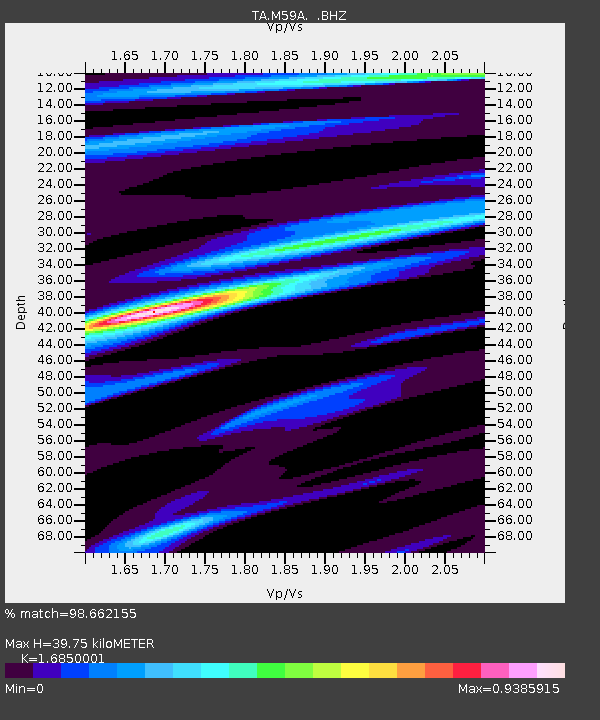
| Estimated Moho Depth: |
39.75 km |
| Estimated Crust Vp/Vs: |
1.69 |
| Assumed Crust Vp: |
6.283 km/s |
| Estimated Crust Vs: |
3.729 km/s |
| Estimated Crust Poisson's Ratio: |
0.23 |
|
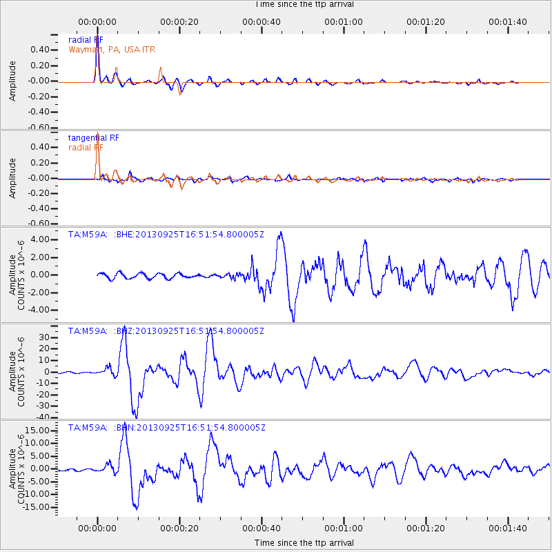
| Radial Match: |
98.662155 % |
| Radial Bump: |
255 |
| Transverse Match: |
95.14261 % |
| Transverse Bump: |
400 |
| SOD ConfigId: |
626651 |
| Insert Time: |
2014-04-18 20:42:24.577 +0000 |
| GWidth: |
2.5 |
| Max Bumps: |
400 |
| Tol: |
0.001 |
|
Signal To Noise
| Channel | StoN | STA | LTA |
| TA:M59A: :BHZ:20130925T16:51:54.800005Z | 7.074536 | 3.229403E-6 | 4.564827E-7 |
| TA:M59A: :BHN:20130925T16:51:54.800005Z | 9.490023 | 1.5662409E-6 | 1.650408E-7 |
| TA:M59A: :BHE:20130925T16:51:54.800005Z | 0.7885542 | 2.2131944E-7 | 2.8066486E-7 |
| Arrivals |
| Ps | 4.6 SECOND |
| PpPs | 16 SECOND |
| PsPs/PpSs | 21 SECOND |


