You are here: Home > Network List > TA - USArray Transportable Network (new EarthScope stations) Stations List
> Station N54A Moraine State Park, Portersville, PA, USA > Earthquake Result Viewer
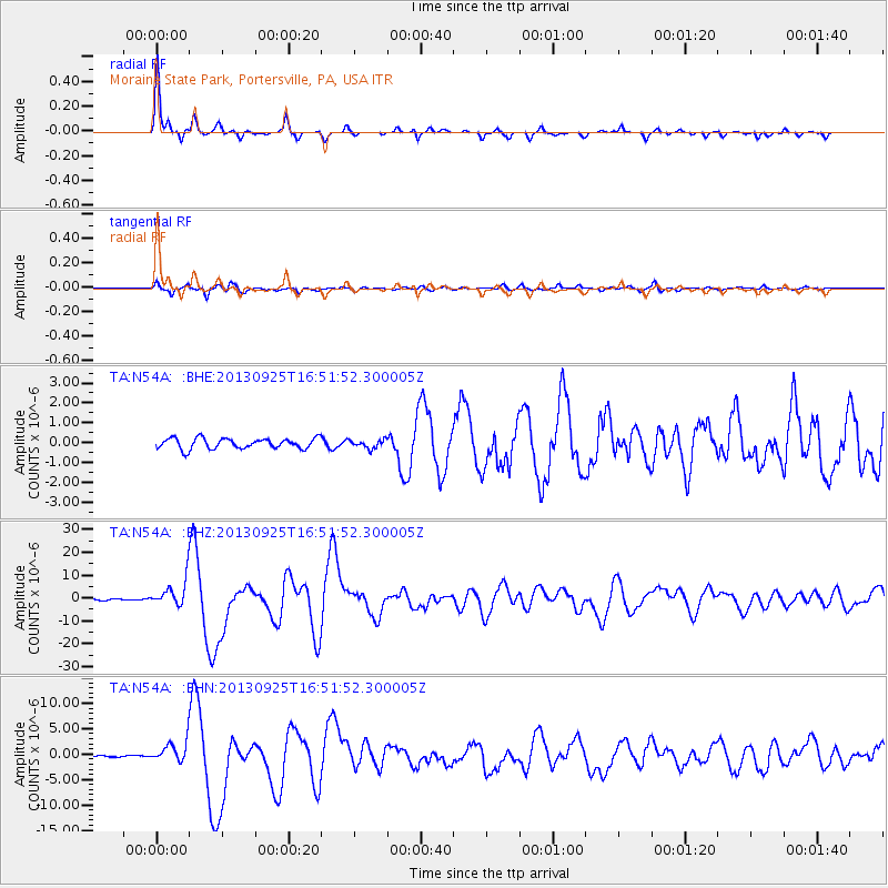
N54A Moraine State Park, Portersville, PA, USA - Earthquake Result Viewer

| Earthquake location: |
Near Coast Of Peru |
| Earthquake latitude/longitude: |
-15.8/-74.5 |
| Earthquake time(UTC): |
2013/09/25 (268) 16:42:43 GMT |
| Earthquake Depth: |
40 km |
| Earthquake Magnitude: |
7.1 MWW, 6.8 MI, 7.0 MWB, 7.0 MWC, 7.1 MWW, 7.1 MWC |
| Earthquake Catalog/Contributor: |
NEIC PDE/NEIC COMCAT |
|
| Network: |
TA USArray Transportable Network (new EarthScope stations) |
| Station: |
N54A Moraine State Park, Portersville, PA, USA |
| Lat/Lon: |
40.96 N/79.99 W |
| Elevation: |
408 m |
|
| Distance: |
56.7 deg |
| Az: |
355.04 deg |
| Baz: |
173.691 deg |
| Ray Param: |
0.06386349 |
| Estimated Moho Depth: |
46.25 km |
| Estimated Crust Vp/Vs: |
1.74 |
| Assumed Crust Vp: |
6.121 km/s |
| Estimated Crust Vs: |
3.528 km/s |
| Estimated Crust Poisson's Ratio: |
0.25 |
|
| Radial Match: |
96.65181 % |
| Radial Bump: |
233 |
| Transverse Match: |
89.19056 % |
| Transverse Bump: |
400 |
| SOD ConfigId: |
626651 |
| Insert Time: |
2014-04-18 20:43:09.250 +0000 |
| GWidth: |
2.5 |
| Max Bumps: |
400 |
| Tol: |
0.001 |
|
Signal To Noise
| Channel | StoN | STA | LTA |
| TA:N54A: :BHZ:20130925T16:51:52.300005Z | 26.540554 | 5.6910585E-6 | 2.1442878E-7 |
| TA:N54A: :BHN:20130925T16:51:52.300005Z | 8.585349 | 2.0031828E-6 | 2.3332574E-7 |
| TA:N54A: :BHE:20130925T16:51:52.300005Z | 0.8104731 | 2.1397643E-7 | 2.6401423E-7 |
| Arrivals |
| Ps | 5.8 SECOND |
| PpPs | 20 SECOND |
| PsPs/PpSs | 26 SECOND |


