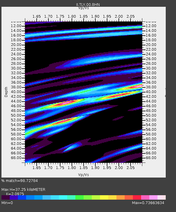
TLY Talaya, Russia - Earthquake Result Viewer

Earthquake location: Kodiak Island Region, Alaska
Earthquake latitude/longitude: 56.4/-152.9
Earthquake time(UTC): 1999/05/07 (127) 14:13:52 GMT
Earthquake Depth: 20 km
Earthquake Magnitude: 5.7 MB, 6.1 MS, 6.4 MW, 5.7 ME
Earthquake Catalog/Contributor: WHDF/NEIC
Network: II Global Seismograph Network (GSN - IRIS/IDA)
Station: TLY Talaya, Russia
Lat/Lon: 51.68 N/103.64 E
Elevation: 579 m
Distance: 55.2 deg
Az: 312.503 deg
Baz: 41.153 deg
Ray Param: 0.06490559
Estimated Moho Depth: 37.25 km
Estimated Crust Vp/Vs: 2.10
Assumed Crust Vp: 6.419 km/s
Estimated Crust Vs: 3.06 km/s
Estimated Crust Poisson's Ratio: 0.35
Radial Match: 98.72784 %
Radial Bump: 305
Transverse Match: 90.669754 %
Transverse Bump: 400
SOD ConfigId: 4480
Insert Time: 2010-03-01 16:58:31.224 +0000
GWidth: 2.5
Max Bumps: 400
Tol: 0.001

Signal To Noise

ChannelStoNSTALTA
II:TLY:00:BHN:19990507T14:22:52.940017Z20.0107751.0730832E-65.3625275E-8
II:TLY:00:BHE:19990507T14:22:52.940017Z17.5750945.412116E-73.0794236E-8
II:TLY:00:BHZ:19990507T14:22:52.940017Z9.4363853.616867E-73.8328945E-8
Arrivals
Ps6.7 SECOND
PpPs17 SECOND
PsPs/PpSs24 SECOND