You are here: Home > Network List > TA - USArray Transportable Network (new EarthScope stations) Stations List
> Station N58A Sunbury, PA, USA > Earthquake Result Viewer
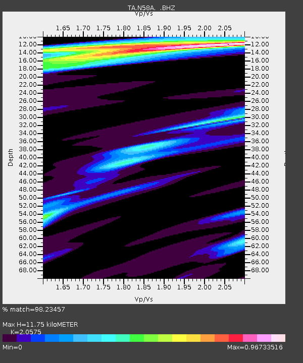
N58A Sunbury, PA, USA - Earthquake Result Viewer
| Earthquake location: |
Near Coast Of Peru |
| Earthquake latitude/longitude: |
-15.8/-74.5 |
| Earthquake time(UTC): |
2013/09/25 (268) 16:42:43 GMT |
| Earthquake Depth: |
40 km |
| Earthquake Magnitude: |
7.1 MWW, 6.8 MI, 7.0 MWB, 7.0 MWC, 7.1 MWW, 7.1 MWC |
| Earthquake Catalog/Contributor: |
NEIC PDE/NEIC COMCAT |
|
| Network: |
TA USArray Transportable Network (new EarthScope stations) |
| Station: |
N58A Sunbury, PA, USA |
| Lat/Lon: |
40.84 N/76.72 W |
| Elevation: |
200 m |
|
| Distance: |
56.4 deg |
| Az: |
357.992 deg |
| Baz: |
177.453 deg |
| Ray Param: |
0.06406893 |
| Estimated Moho Depth: |
11.75 km |
| Estimated Crust Vp/Vs: |
2.06 |
| Assumed Crust Vp: |
6.121 km/s |
| Estimated Crust Vs: |
2.975 km/s |
| Estimated Crust Poisson's Ratio: |
0.35 |
|
| Radial Match: |
98.23457 % |
| Radial Bump: |
215 |
| Transverse Match: |
95.68415 % |
| Transverse Bump: |
400 |
| SOD ConfigId: |
626651 |
| Insert Time: |
2014-04-18 20:43:26.271 +0000 |
| GWidth: |
2.5 |
| Max Bumps: |
400 |
| Tol: |
0.001 |
|

Signal To Noise
| Channel | StoN | STA | LTA |
| TA:N58A: :BHZ:20130925T16:51:50.075029Z | 14.970978 | 3.821249E-6 | 2.5524378E-7 |
| TA:N58A: :BHN:20130925T16:51:50.075029Z | 7.668782 | 1.3529191E-6 | 1.7641902E-7 |
| TA:N58A: :BHE:20130925T16:51:50.075029Z | 0.88028324 | 1.5463644E-7 | 1.7566668E-7 |
| Arrivals |
| Ps | 2.1 SECOND |
| PpPs | 5.6 SECOND |
| PsPs/PpSs | 7.8 SECOND |


