You are here: Home > Network List > TA - USArray Transportable Network (new EarthScope stations) Stations List
> Station N61A South Mountain, Millburn, NJ, USA > Earthquake Result Viewer
N61A South Mountain, Millburn, NJ, USA - Earthquake Result Viewer
| Earthquake location: |
Near Coast Of Peru |
| Earthquake latitude/longitude: |
-15.8/-74.5 |
| Earthquake time(UTC): |
2013/09/25 (268) 16:42:43 GMT |
| Earthquake Depth: |
40 km |
| Earthquake Magnitude: |
7.1 MWW, 6.8 MI, 7.0 MWB, 7.0 MWC, 7.1 MWW, 7.1 MWC |
| Earthquake Catalog/Contributor: |
NEIC PDE/NEIC COMCAT |
|
| Network: |
TA USArray Transportable Network (new EarthScope stations) |
| Station: |
N61A South Mountain, Millburn, NJ, USA |
| Lat/Lon: |
40.75 N/74.30 W |
| Elevation: |
108 m |
|
| Distance: |
56.3 deg |
| Az: |
0.196 deg |
| Baz: |
180.248 deg |
| Ray Param: |
0.064149834 |
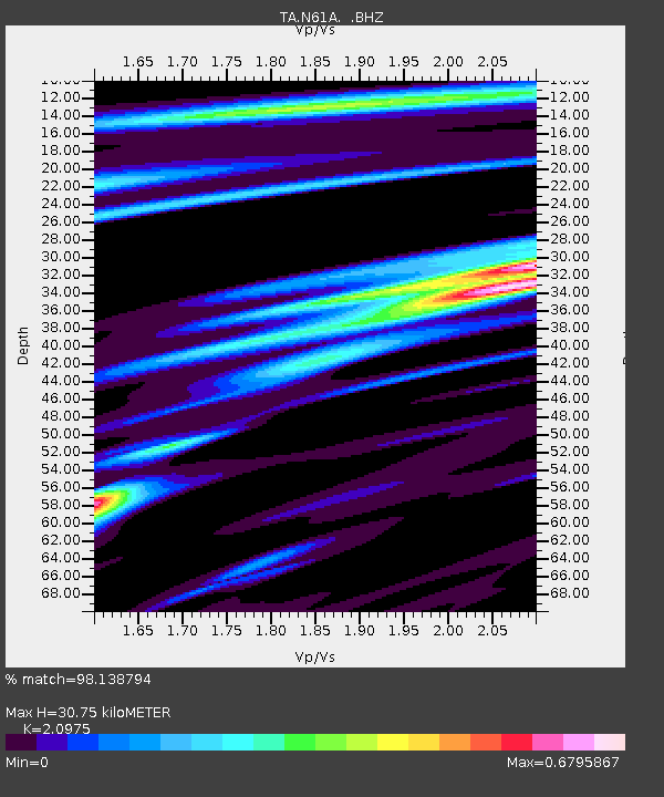
| Estimated Moho Depth: |
30.75 km |
| Estimated Crust Vp/Vs: |
2.10 |
| Assumed Crust Vp: |
6.283 km/s |
| Estimated Crust Vs: |
2.996 km/s |
| Estimated Crust Poisson's Ratio: |
0.35 |
|
| Radial Match: |
98.138794 % |
| Radial Bump: |
220 |
| Transverse Match: |
91.80243 % |
| Transverse Bump: |
400 |
| SOD ConfigId: |
626651 |
| Insert Time: |
2014-04-18 20:43:34.460 +0000 |
| GWidth: |
2.5 |
| Max Bumps: |
400 |
| Tol: |
0.001 |
|

Signal To Noise
| Channel | StoN | STA | LTA |
| TA:N61A: :BHZ:20130925T16:51:49.175005Z | 7.4300566 | 2.567964E-6 | 3.4561836E-7 |
| TA:N61A: :BHN:20130925T16:51:49.175005Z | 2.7026932 | 1.3351527E-6 | 4.9400825E-7 |
| TA:N61A: :BHE:20130925T16:51:49.175005Z | 0.8694647 | 2.815538E-7 | 3.2382428E-7 |
| Arrivals |
| Ps | 5.6 SECOND |
| PpPs | 15 SECOND |
| PsPs/PpSs | 20 SECOND |


