You are here: Home > Network List > YT07 - POLENET Stations List
> Station WHIT WHIT > Earthquake Result Viewer
WHIT WHIT - Earthquake Result Viewer
| Earthquake location: |
Northern Molucca Sea |
| Earthquake latitude/longitude: |
1.9/126.5 |
| Earthquake time(UTC): |
2014/11/26 (330) 14:33:43 GMT |
| Earthquake Depth: |
39 km |
| Earthquake Magnitude: |
6.8 MWW, 6.8 MWC, 6.8 MWB, 7.0 MI |
| Earthquake Catalog/Contributor: |
NEIC PDE/NEIC COMCAT |
|
| Network: |
YT POLENET |
| Station: |
WHIT WHIT |
| Lat/Lon: |
82.68 S/104.39 W |
| Elevation: |
2343 m |
|
| Distance: |
96.5 deg |
| Az: |
174.251 deg |
| Baz: |
231.341 deg |
| Ray Param: |
0.04046446 |
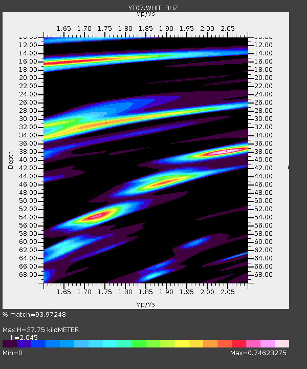
| Estimated Moho Depth: |
37.75 km |
| Estimated Crust Vp/Vs: |
2.05 |
| Assumed Crust Vp: |
6.356 km/s |
| Estimated Crust Vs: |
3.108 km/s |
| Estimated Crust Poisson's Ratio: |
0.34 |
|
| Radial Match: |
93.97248 % |
| Radial Bump: |
400 |
| Transverse Match: |
87.69598 % |
| Transverse Bump: |
400 |
| SOD ConfigId: |
3390531 |
| Insert Time: |
2019-04-15 05:01:59.358 +0000 |
| GWidth: |
2.5 |
| Max Bumps: |
400 |
| Tol: |
0.001 |
|

Signal To Noise
| Channel | StoN | STA | LTA |
| YT:WHIT: :BHZ:20141126T14:46:38.448989Z | 13.630628 | 9.149174E-7 | 6.712218E-8 |
| YT:WHIT: :BHN:20141126T14:46:38.448989Z | 2.8251457 | 1.8190033E-7 | 6.438618E-8 |
| YT:WHIT: :BHE:20141126T14:46:38.448989Z | 5.944112 | 2.3376808E-7 | 3.932767E-8 |
| Arrivals |
| Ps | 6.3 SECOND |
| PpPs | 18 SECOND |
| PsPs/PpSs | 24 SECOND |


