You are here: Home > Network List > TA - USArray Transportable Network (new EarthScope stations) Stations List
> Station O59A Robesonia, PA, USA > Earthquake Result Viewer
O59A Robesonia, PA, USA - Earthquake Result Viewer
| Earthquake location: |
Near Coast Of Peru |
| Earthquake latitude/longitude: |
-15.8/-74.5 |
| Earthquake time(UTC): |
2013/09/25 (268) 16:42:43 GMT |
| Earthquake Depth: |
40 km |
| Earthquake Magnitude: |
7.1 MWW, 6.8 MI, 7.0 MWB, 7.0 MWC, 7.1 MWW, 7.1 MWC |
| Earthquake Catalog/Contributor: |
NEIC PDE/NEIC COMCAT |
|
| Network: |
TA USArray Transportable Network (new EarthScope stations) |
| Station: |
O59A Robesonia, PA, USA |
| Lat/Lon: |
40.31 N/76.19 W |
| Elevation: |
334 m |
|
| Distance: |
55.9 deg |
| Az: |
358.453 deg |
| Baz: |
178.053 deg |
| Ray Param: |
0.06442202 |
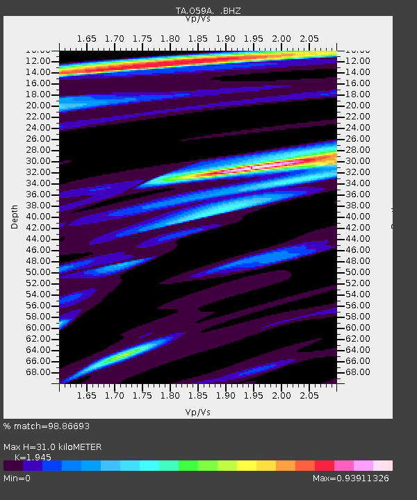
| Estimated Moho Depth: |
31.0 km |
| Estimated Crust Vp/Vs: |
1.95 |
| Assumed Crust Vp: |
6.121 km/s |
| Estimated Crust Vs: |
3.147 km/s |
| Estimated Crust Poisson's Ratio: |
0.32 |
|
| Radial Match: |
98.86693 % |
| Radial Bump: |
197 |
| Transverse Match: |
91.01673 % |
| Transverse Bump: |
400 |
| SOD ConfigId: |
626651 |
| Insert Time: |
2014-04-18 20:44:11.495 +0000 |
| GWidth: |
2.5 |
| Max Bumps: |
400 |
| Tol: |
0.001 |
|

Signal To Noise
| Channel | StoN | STA | LTA |
| TA:O59A: :BHZ:20130925T16:51:46.200029Z | 12.859721 | 2.8116046E-6 | 2.1863653E-7 |
| TA:O59A: :BHN:20130925T16:51:46.200029Z | 8.002926 | 1.3882471E-6 | 1.7346746E-7 |
| TA:O59A: :BHE:20130925T16:51:46.200029Z | 1.2198821 | 1.7580864E-7 | 1.4411937E-7 |
| Arrivals |
| Ps | 5.0 SECOND |
| PpPs | 14 SECOND |
| PsPs/PpSs | 19 SECOND |


