You are here: Home > Network List > TA - USArray Transportable Network (new EarthScope stations) Stations List
> Station O60A Telford, PA, USA > Earthquake Result Viewer
O60A Telford, PA, USA - Earthquake Result Viewer
| Earthquake location: |
Near Coast Of Peru |
| Earthquake latitude/longitude: |
-15.8/-74.5 |
| Earthquake time(UTC): |
2013/09/25 (268) 16:42:43 GMT |
| Earthquake Depth: |
40 km |
| Earthquake Magnitude: |
7.1 MWW, 6.8 MI, 7.0 MWB, 7.0 MWC, 7.1 MWW, 7.1 MWC |
| Earthquake Catalog/Contributor: |
NEIC PDE/NEIC COMCAT |
|
| Network: |
TA USArray Transportable Network (new EarthScope stations) |
| Station: |
O60A Telford, PA, USA |
| Lat/Lon: |
40.32 N/75.40 W |
| Elevation: |
70 m |
|
| Distance: |
55.9 deg |
| Az: |
359.174 deg |
| Baz: |
178.961 deg |
| Ray Param: |
0.064428054 |
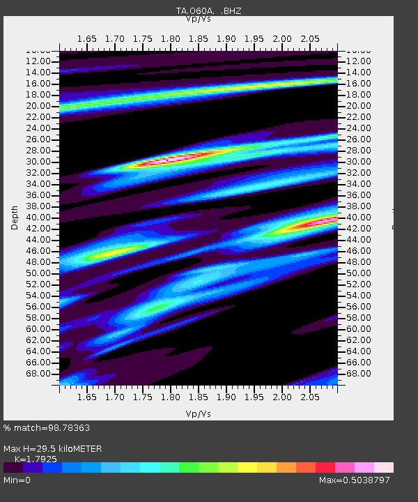
| Estimated Moho Depth: |
29.5 km |
| Estimated Crust Vp/Vs: |
1.79 |
| Assumed Crust Vp: |
6.283 km/s |
| Estimated Crust Vs: |
3.505 km/s |
| Estimated Crust Poisson's Ratio: |
0.27 |
|
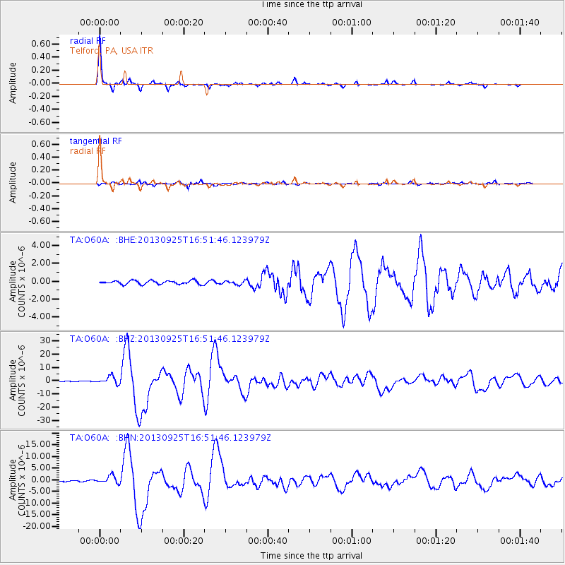
| Radial Match: |
98.78363 % |
| Radial Bump: |
173 |
| Transverse Match: |
94.4204 % |
| Transverse Bump: |
376 |
| SOD ConfigId: |
626651 |
| Insert Time: |
2014-04-18 20:44:12.224 +0000 |
| GWidth: |
2.5 |
| Max Bumps: |
400 |
| Tol: |
0.001 |
|
Signal To Noise
| Channel | StoN | STA | LTA |
| TA:O60A: :BHZ:20130925T16:51:46.123979Z | 14.749062 | 2.947887E-6 | 1.9986948E-7 |
| TA:O60A: :BHN:20130925T16:51:46.123979Z | 10.574345 | 1.6932347E-6 | 1.6012667E-7 |
| TA:O60A: :BHE:20130925T16:51:46.123979Z | 0.98074347 | 1.9719097E-7 | 2.0106275E-7 |
| Arrivals |
| Ps | 3.9 SECOND |
| PpPs | 12 SECOND |
| PsPs/PpSs | 16 SECOND |


