You are here: Home > Network List > TA - USArray Transportable Network (new EarthScope stations) Stations List
> Station P55A Reedsville, WV, USA > Earthquake Result Viewer
P55A Reedsville, WV, USA - Earthquake Result Viewer

| Earthquake location: |
Near Coast Of Peru |
| Earthquake latitude/longitude: |
-15.8/-74.5 |
| Earthquake time(UTC): |
2013/09/25 (268) 16:42:43 GMT |
| Earthquake Depth: |
40 km |
| Earthquake Magnitude: |
7.1 MWW, 6.8 MI, 7.0 MWB, 7.0 MWC, 7.1 MWW, 7.1 MWC |
| Earthquake Catalog/Contributor: |
NEIC PDE/NEIC COMCAT |
|
| Network: |
TA USArray Transportable Network (new EarthScope stations) |
| Station: |
P55A Reedsville, WV, USA |
| Lat/Lon: |
39.51 N/79.83 W |
| Elevation: |
551 m |
|
| Distance: |
55.3 deg |
| Az: |
354.998 deg |
| Baz: |
173.772 deg |
| Ray Param: |
0.06481272 |
| Estimated Moho Depth: |
41.25 km |
| Estimated Crust Vp/Vs: |
1.84 |
| Assumed Crust Vp: |
6.159 km/s |
| Estimated Crust Vs: |
3.356 km/s |
| Estimated Crust Poisson's Ratio: |
0.29 |
|
| Radial Match: |
96.80949 % |
| Radial Bump: |
245 |
| Transverse Match: |
90.80073 % |
| Transverse Bump: |
366 |
| SOD ConfigId: |
626651 |
| Insert Time: |
2014-04-18 20:44:40.161 +0000 |
| GWidth: |
2.5 |
| Max Bumps: |
400 |
| Tol: |
0.001 |
|
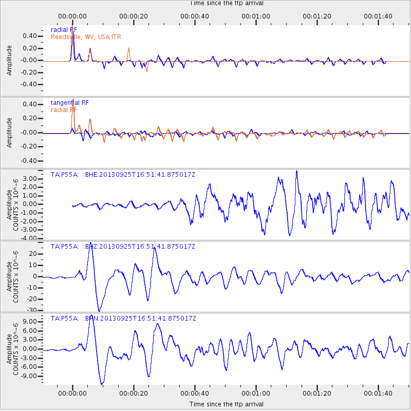
Signal To Noise
| Channel | StoN | STA | LTA |
| TA:P55A: :BHZ:20130925T16:51:41.875017Z | 8.952107 | 3.0306678E-6 | 3.3854238E-7 |
| TA:P55A: :BHN:20130925T16:51:41.875017Z | 5.7251873 | 1.1281572E-6 | 1.9705158E-7 |
| TA:P55A: :BHE:20130925T16:51:41.875017Z | 1.7587407 | 3.234264E-7 | 1.8389659E-7 |
| Arrivals |
| Ps | 5.9 SECOND |
| PpPs | 18 SECOND |
| PsPs/PpSs | 24 SECOND |


