You are here: Home > Network List > ZJ12 - Transantarctic Mountains Northern Network Stations List
> Station SHRD Lister Nunataks, Antarctica > Earthquake Result Viewer
SHRD Lister Nunataks, Antarctica - Earthquake Result Viewer
| Earthquake location: |
Northern Molucca Sea |
| Earthquake latitude/longitude: |
1.9/126.5 |
| Earthquake time(UTC): |
2014/11/26 (330) 14:33:43 GMT |
| Earthquake Depth: |
39 km |
| Earthquake Magnitude: |
6.8 MWW, 6.8 MWC, 6.8 MWB, 7.0 MI |
| Earthquake Catalog/Contributor: |
NEIC PDE/NEIC COMCAT |
|
| Network: |
ZJ Transantarctic Mountains Northern Network |
| Station: |
SHRD Lister Nunataks, Antarctica |
| Lat/Lon: |
73.40 S/160.50 E |
| Elevation: |
2457 m |
|
| Distance: |
78.1 deg |
| Az: |
170.552 deg |
| Baz: |
325.2 deg |
| Ray Param: |
0.049816735 |
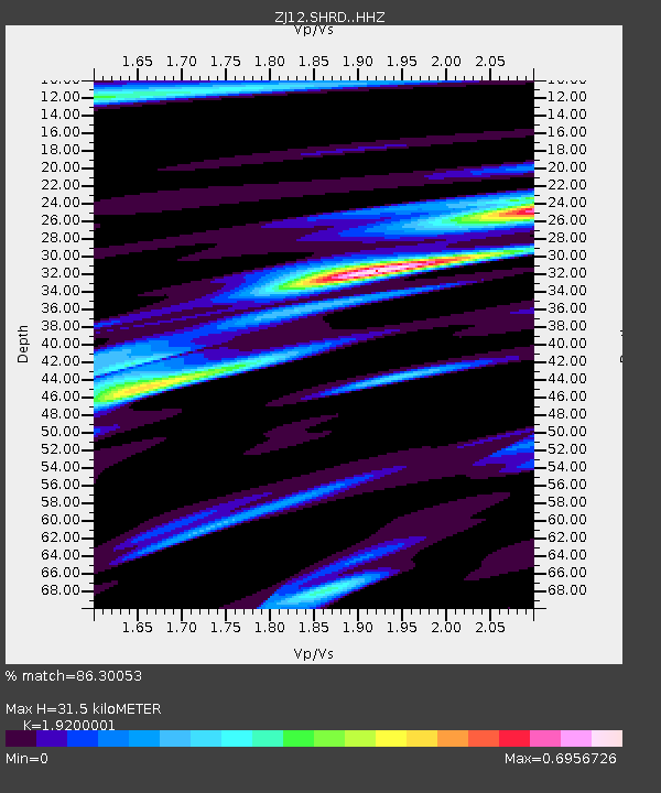
| Estimated Moho Depth: |
31.5 km |
| Estimated Crust Vp/Vs: |
1.92 |
| Assumed Crust Vp: |
6.264 km/s |
| Estimated Crust Vs: |
3.263 km/s |
| Estimated Crust Poisson's Ratio: |
0.31 |
|
| Radial Match: |
86.30053 % |
| Radial Bump: |
400 |
| Transverse Match: |
79.48636 % |
| Transverse Bump: |
400 |
| SOD ConfigId: |
3390531 |
| Insert Time: |
2019-04-15 05:02:16.104 +0000 |
| GWidth: |
2.5 |
| Max Bumps: |
400 |
| Tol: |
0.001 |
|

Signal To Noise
| Channel | StoN | STA | LTA |
| ZJ:SHRD: :HHZ:20141126T14:45:08.308975Z | 3.58937 | 3.2068847E-6 | 8.9343945E-7 |
| ZJ:SHRD: :HHN:20141126T14:45:08.308975Z | 27.149801 | 1.2247892E-6 | 4.5112273E-8 |
| ZJ:SHRD: :HHE:20141126T14:45:08.308975Z | 18.867954 | 8.2542465E-7 | 4.3747434E-8 |
| Arrivals |
| Ps | 4.7 SECOND |
| PpPs | 14 SECOND |
| PsPs/PpSs | 19 SECOND |


