You are here: Home > Network List > TA - USArray Transportable Network (new EarthScope stations) Stations List
> Station P58A Pank, Wackersville, MD, USA > Earthquake Result Viewer
P58A Pank, Wackersville, MD, USA - Earthquake Result Viewer
| Earthquake location: |
Near Coast Of Peru |
| Earthquake latitude/longitude: |
-15.8/-74.5 |
| Earthquake time(UTC): |
2013/09/25 (268) 16:42:43 GMT |
| Earthquake Depth: |
40 km |
| Earthquake Magnitude: |
7.1 MWW, 6.8 MI, 7.0 MWB, 7.0 MWC, 7.1 MWW, 7.1 MWC |
| Earthquake Catalog/Contributor: |
NEIC PDE/NEIC COMCAT |
|
| Network: |
TA USArray Transportable Network (new EarthScope stations) |
| Station: |
P58A Pank, Wackersville, MD, USA |
| Lat/Lon: |
39.49 N/77.30 W |
| Elevation: |
139 m |
|
| Distance: |
55.1 deg |
| Az: |
357.368 deg |
| Baz: |
176.726 deg |
| Ray Param: |
0.06493177 |
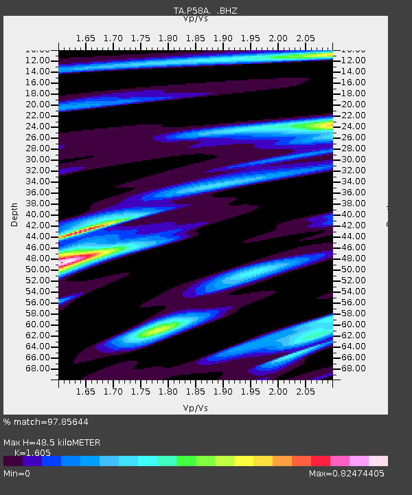
| Estimated Moho Depth: |
48.5 km |
| Estimated Crust Vp/Vs: |
1.61 |
| Assumed Crust Vp: |
6.419 km/s |
| Estimated Crust Vs: |
4.0 km/s |
| Estimated Crust Poisson's Ratio: |
0.18 |
|
| Radial Match: |
97.85644 % |
| Radial Bump: |
318 |
| Transverse Match: |
90.42492 % |
| Transverse Bump: |
400 |
| SOD ConfigId: |
626651 |
| Insert Time: |
2014-04-18 20:44:46.998 +0000 |
| GWidth: |
2.5 |
| Max Bumps: |
400 |
| Tol: |
0.001 |
|

Signal To Noise
| Channel | StoN | STA | LTA |
| TA:P58A: :BHZ:20130925T16:51:40.575029Z | 15.733438 | 2.7545082E-6 | 1.7507351E-7 |
| TA:P58A: :BHN:20130925T16:51:40.575029Z | 13.61953 | 1.8945188E-6 | 1.3910311E-7 |
| TA:P58A: :BHE:20130925T16:51:40.575029Z | 1.1031218 | 2.0981551E-7 | 1.9020159E-7 |
| Arrivals |
| Ps | 4.8 SECOND |
| PpPs | 19 SECOND |
| PsPs/PpSs | 23 SECOND |


