You are here: Home > Network List > TA - USArray Transportable Network (new EarthScope stations) Stations List
> Station Q24A Divide, CO, USA > Earthquake Result Viewer
Q24A Divide, CO, USA - Earthquake Result Viewer

| Earthquake location: |
Near Coast Of Peru |
| Earthquake latitude/longitude: |
-15.8/-74.5 |
| Earthquake time(UTC): |
2013/09/25 (268) 16:42:43 GMT |
| Earthquake Depth: |
40 km |
| Earthquake Magnitude: |
7.1 MWW, 6.8 MI, 7.0 MWB, 7.0 MWC, 7.1 MWW, 7.1 MWC |
| Earthquake Catalog/Contributor: |
NEIC PDE/NEIC COMCAT |
|
| Network: |
TA USArray Transportable Network (new EarthScope stations) |
| Station: |
Q24A Divide, CO, USA |
| Lat/Lon: |
38.96 N/105.15 W |
| Elevation: |
2775 m |
|
| Distance: |
61.6 deg |
| Az: |
333.148 deg |
| Baz: |
146.106 deg |
| Ray Param: |
0.06070123 |
| Estimated Moho Depth: |
52.0 km |
| Estimated Crust Vp/Vs: |
1.69 |
| Assumed Crust Vp: |
6.159 km/s |
| Estimated Crust Vs: |
3.65 km/s |
| Estimated Crust Poisson's Ratio: |
0.23 |
|
| Radial Match: |
98.12904 % |
| Radial Bump: |
337 |
| Transverse Match: |
96.234314 % |
| Transverse Bump: |
381 |
| SOD ConfigId: |
626651 |
| Insert Time: |
2014-04-18 20:45:01.088 +0000 |
| GWidth: |
2.5 |
| Max Bumps: |
400 |
| Tol: |
0.001 |
|
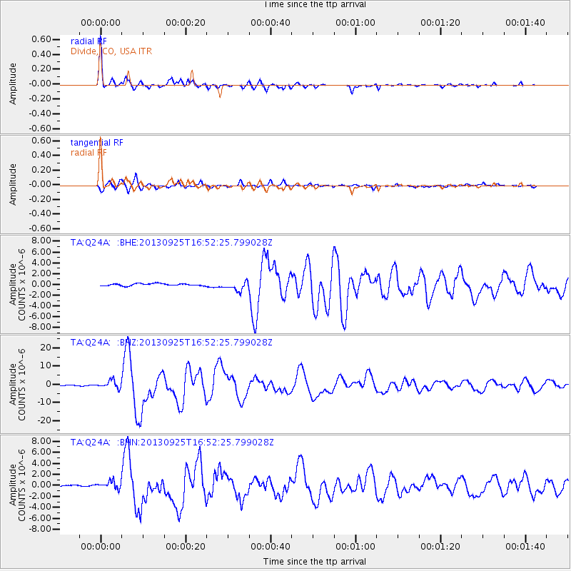
Signal To Noise
| Channel | StoN | STA | LTA |
| TA:Q24A: :BHZ:20130925T16:52:25.799028Z | 13.555139 | 2.220075E-6 | 1.6378107E-7 |
| TA:Q24A: :BHN:20130925T16:52:25.799028Z | 5.1976666 | 7.4426845E-7 | 1.431928E-7 |
| TA:Q24A: :BHE:20130925T16:52:25.799028Z | 4.551476 | 8.941084E-7 | 1.9644361E-7 |
| Arrivals |
| Ps | 6.1 SECOND |
| PpPs | 22 SECOND |
| PsPs/PpSs | 28 SECOND |


