You are here: Home > Network List > TA - USArray Transportable Network (new EarthScope stations) Stations List
> Station Q60A Greensboro, MD, USA > Earthquake Result Viewer
Q60A Greensboro, MD, USA - Earthquake Result Viewer
| Earthquake location: |
Near Coast Of Peru |
| Earthquake latitude/longitude: |
-15.8/-74.5 |
| Earthquake time(UTC): |
2013/09/25 (268) 16:42:43 GMT |
| Earthquake Depth: |
40 km |
| Earthquake Magnitude: |
7.1 MWW, 6.8 MI, 7.0 MWB, 7.0 MWC, 7.1 MWW, 7.1 MWC |
| Earthquake Catalog/Contributor: |
NEIC PDE/NEIC COMCAT |
|
| Network: |
TA USArray Transportable Network (new EarthScope stations) |
| Station: |
Q60A Greensboro, MD, USA |
| Lat/Lon: |
39.00 N/75.84 W |
| Elevation: |
14 m |
|
| Distance: |
54.6 deg |
| Az: |
358.726 deg |
| Baz: |
178.427 deg |
| Ray Param: |
0.065287866 |
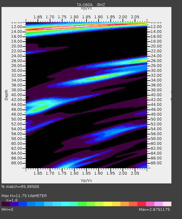
| Estimated Moho Depth: |
11.75 km |
| Estimated Crust Vp/Vs: |
1.80 |
| Assumed Crust Vp: |
6.287 km/s |
| Estimated Crust Vs: |
3.493 km/s |
| Estimated Crust Poisson's Ratio: |
0.28 |
|
| Radial Match: |
95.89588 % |
| Radial Bump: |
363 |
| Transverse Match: |
84.4965 % |
| Transverse Bump: |
400 |
| SOD ConfigId: |
626651 |
| Insert Time: |
2014-04-18 20:45:44.134 +0000 |
| GWidth: |
2.5 |
| Max Bumps: |
400 |
| Tol: |
0.001 |
|
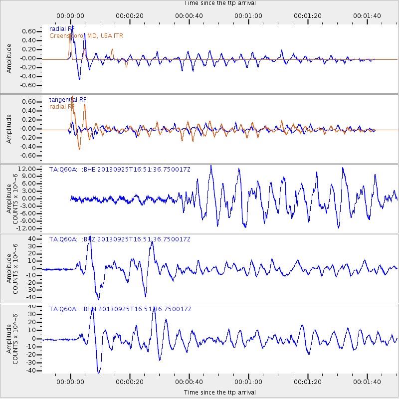
Signal To Noise
| Channel | StoN | STA | LTA |
| TA:Q60A: :BHZ:20130925T16:51:36.750017Z | 12.549214 | 3.9968336E-6 | 3.1849274E-7 |
| TA:Q60A: :BHN:20130925T16:51:36.750017Z | 5.303634 | 2.626999E-6 | 4.953206E-7 |
| TA:Q60A: :BHE:20130925T16:51:36.750017Z | 0.9106913 | 7.3011563E-7 | 8.017158E-7 |
| Arrivals |
| Ps | 1.6 SECOND |
| PpPs | 5.0 SECOND |
| PsPs/PpSs | 6.6 SECOND |


