You are here: Home > Network List > TA - USArray Transportable Network (new EarthScope stations) Stations List
> Station R55A Marlinton, WV, USA > Earthquake Result Viewer
R55A Marlinton, WV, USA - Earthquake Result Viewer
| Earthquake location: |
Near Coast Of Peru |
| Earthquake latitude/longitude: |
-15.8/-74.5 |
| Earthquake time(UTC): |
2013/09/25 (268) 16:42:43 GMT |
| Earthquake Depth: |
40 km |
| Earthquake Magnitude: |
7.1 MWW, 6.8 MI, 7.0 MWB, 7.0 MWC, 7.1 MWW, 7.1 MWC |
| Earthquake Catalog/Contributor: |
NEIC PDE/NEIC COMCAT |
|
| Network: |
TA USArray Transportable Network (new EarthScope stations) |
| Station: |
R55A Marlinton, WV, USA |
| Lat/Lon: |
38.28 N/80.12 W |
| Elevation: |
833 m |
|
| Distance: |
54.1 deg |
| Az: |
354.551 deg |
| Baz: |
173.331 deg |
| Ray Param: |
0.06558417 |
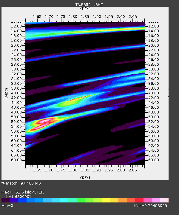
| Estimated Moho Depth: |
51.5 km |
| Estimated Crust Vp/Vs: |
1.68 |
| Assumed Crust Vp: |
6.207 km/s |
| Estimated Crust Vs: |
3.695 km/s |
| Estimated Crust Poisson's Ratio: |
0.23 |
|
| Radial Match: |
97.480446 % |
| Radial Bump: |
257 |
| Transverse Match: |
94.609985 % |
| Transverse Bump: |
400 |
| SOD ConfigId: |
626651 |
| Insert Time: |
2014-04-18 20:46:07.034 +0000 |
| GWidth: |
2.5 |
| Max Bumps: |
400 |
| Tol: |
0.001 |
|

Signal To Noise
| Channel | StoN | STA | LTA |
| TA:R55A: :BHZ:20130925T16:51:33.27498Z | 13.259479 | 2.7771912E-6 | 2.094495E-7 |
| TA:R55A: :BHN:20130925T16:51:33.27498Z | 15.570904 | 1.3888834E-6 | 8.919736E-8 |
| TA:R55A: :BHE:20130925T16:51:33.27498Z | 0.9468429 | 2.1840474E-7 | 2.3066627E-7 |
| Arrivals |
| Ps | 5.9 SECOND |
| PpPs | 21 SECOND |
| PsPs/PpSs | 27 SECOND |


