You are here: Home > Network List > TA - USArray Transportable Network (new EarthScope stations) Stations List
> Station R58A Rapidan, VA, USA > Earthquake Result Viewer
R58A Rapidan, VA, USA - Earthquake Result Viewer
| Earthquake location: |
Near Coast Of Peru |
| Earthquake latitude/longitude: |
-15.8/-74.5 |
| Earthquake time(UTC): |
2013/09/25 (268) 16:42:43 GMT |
| Earthquake Depth: |
40 km |
| Earthquake Magnitude: |
7.1 MWW, 6.8 MI, 7.0 MWB, 7.0 MWC, 7.1 MWW, 7.1 MWC |
| Earthquake Catalog/Contributor: |
NEIC PDE/NEIC COMCAT |
|
| Network: |
TA USArray Transportable Network (new EarthScope stations) |
| Station: |
R58A Rapidan, VA, USA |
| Lat/Lon: |
38.30 N/78.00 W |
| Elevation: |
184 m |
|
| Distance: |
53.9 deg |
| Az: |
356.602 deg |
| Baz: |
175.841 deg |
| Ray Param: |
0.06567194 |
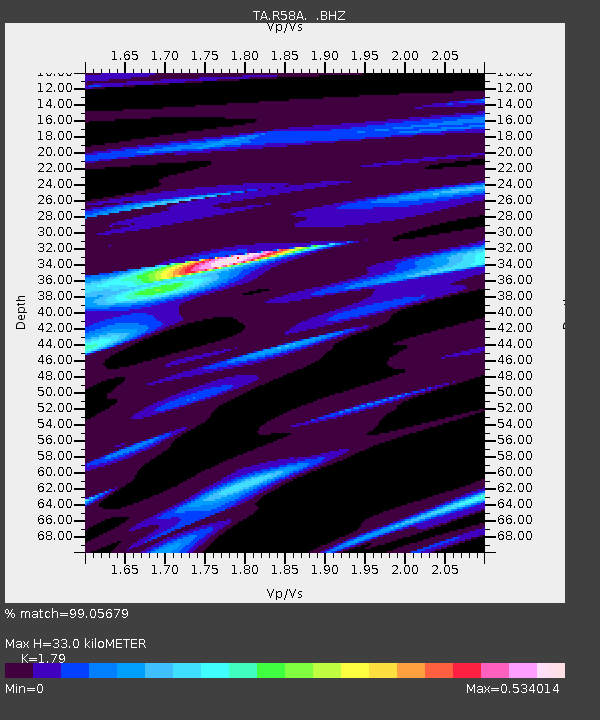
| Estimated Moho Depth: |
33.0 km |
| Estimated Crust Vp/Vs: |
1.79 |
| Assumed Crust Vp: |
6.159 km/s |
| Estimated Crust Vs: |
3.441 km/s |
| Estimated Crust Poisson's Ratio: |
0.27 |
|
| Radial Match: |
99.05679 % |
| Radial Bump: |
188 |
| Transverse Match: |
87.91025 % |
| Transverse Bump: |
400 |
| SOD ConfigId: |
626651 |
| Insert Time: |
2014-04-18 20:46:14.337 +0000 |
| GWidth: |
2.5 |
| Max Bumps: |
400 |
| Tol: |
0.001 |
|
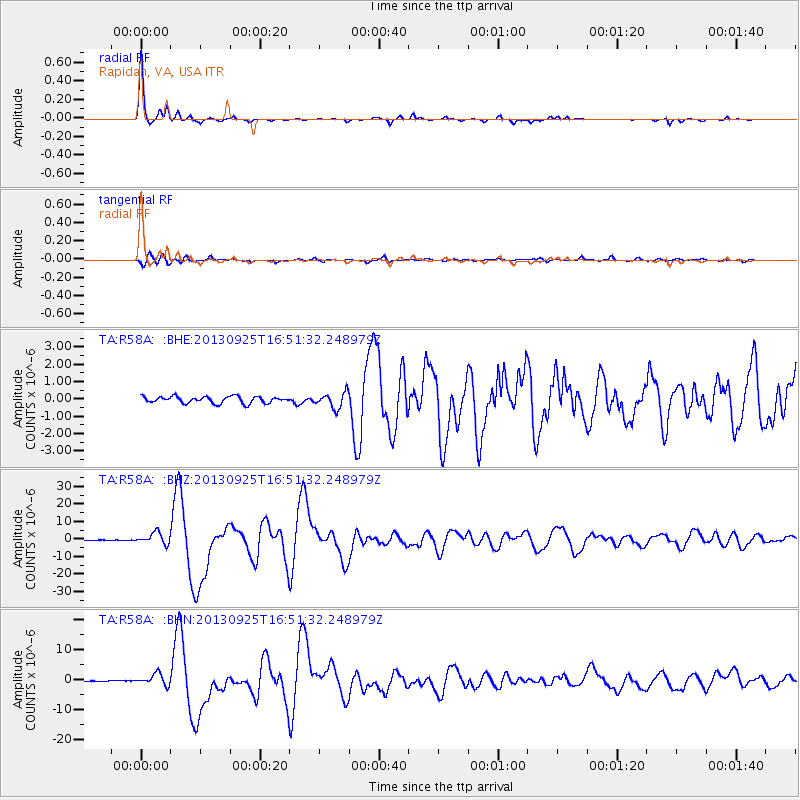
Signal To Noise
| Channel | StoN | STA | LTA |
| TA:R58A: :BHZ:20130925T16:51:32.248979Z | 25.55838 | 3.264305E-6 | 1.2771955E-7 |
| TA:R58A: :BHN:20130925T16:51:32.248979Z | 17.509455 | 1.898404E-6 | 1.08421645E-7 |
| TA:R58A: :BHE:20130925T16:51:32.248979Z | 2.3568354 | 4.4946796E-7 | 1.9070825E-7 |
| Arrivals |
| Ps | 4.4 SECOND |
| PpPs | 14 SECOND |
| PsPs/PpSs | 19 SECOND |


