You are here: Home > Network List > TA - USArray Transportable Network (new EarthScope stations) Stations List
> Station R58B Mineral, VA, USA > Earthquake Result Viewer
R58B Mineral, VA, USA - Earthquake Result Viewer
| Earthquake location: |
Near Coast Of Peru |
| Earthquake latitude/longitude: |
-15.8/-74.5 |
| Earthquake time(UTC): |
2013/09/25 (268) 16:42:43 GMT |
| Earthquake Depth: |
40 km |
| Earthquake Magnitude: |
7.1 MWW, 6.8 MI, 7.0 MWB, 7.0 MWC, 7.1 MWW, 7.1 MWC |
| Earthquake Catalog/Contributor: |
NEIC PDE/NEIC COMCAT |
|
| Network: |
TA USArray Transportable Network (new EarthScope stations) |
| Station: |
R58B Mineral, VA, USA |
| Lat/Lon: |
37.96 N/77.88 W |
| Elevation: |
116 m |
|
| Distance: |
53.6 deg |
| Az: |
356.694 deg |
| Baz: |
175.972 deg |
| Ray Param: |
0.065898284 |
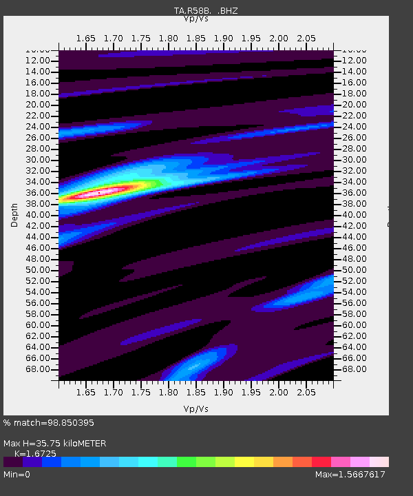
| Estimated Moho Depth: |
35.75 km |
| Estimated Crust Vp/Vs: |
1.67 |
| Assumed Crust Vp: |
6.565 km/s |
| Estimated Crust Vs: |
3.925 km/s |
| Estimated Crust Poisson's Ratio: |
0.22 |
|
| Radial Match: |
98.850395 % |
| Radial Bump: |
190 |
| Transverse Match: |
92.45134 % |
| Transverse Bump: |
400 |
| SOD ConfigId: |
626651 |
| Insert Time: |
2014-04-18 20:46:15.853 +0000 |
| GWidth: |
2.5 |
| Max Bumps: |
400 |
| Tol: |
0.001 |
|

Signal To Noise
| Channel | StoN | STA | LTA |
| TA:R58B: :BHZ:20130925T16:51:29.77498Z | 24.924747 | 3.3143153E-6 | 1.3297287E-7 |
| TA:R58B: :BHN:20130925T16:51:29.77498Z | 10.924246 | 1.8902056E-6 | 1.7302847E-7 |
| TA:R58B: :BHE:20130925T16:51:29.77498Z | 2.2246256 | 2.4602016E-7 | 1.1058947E-7 |
| Arrivals |
| Ps | 3.9 SECOND |
| PpPs | 14 SECOND |
| PsPs/PpSs | 18 SECOND |


