You are here: Home > Network List > TA - USArray Transportable Network (new EarthScope stations) Stations List
> Station S51A Beattyville, KY, USA > Earthquake Result Viewer
S51A Beattyville, KY, USA - Earthquake Result Viewer
| Earthquake location: |
Near Coast Of Peru |
| Earthquake latitude/longitude: |
-15.8/-74.5 |
| Earthquake time(UTC): |
2013/09/25 (268) 16:42:43 GMT |
| Earthquake Depth: |
40 km |
| Earthquake Magnitude: |
7.1 MWW, 6.8 MI, 7.0 MWB, 7.0 MWC, 7.1 MWW, 7.1 MWC |
| Earthquake Catalog/Contributor: |
NEIC PDE/NEIC COMCAT |
|
| Network: |
TA USArray Transportable Network (new EarthScope stations) |
| Station: |
S51A Beattyville, KY, USA |
| Lat/Lon: |
37.64 N/83.59 W |
| Elevation: |
286 m |
|
| Distance: |
53.9 deg |
| Az: |
351.075 deg |
| Baz: |
169.158 deg |
| Ray Param: |
0.065720804 |
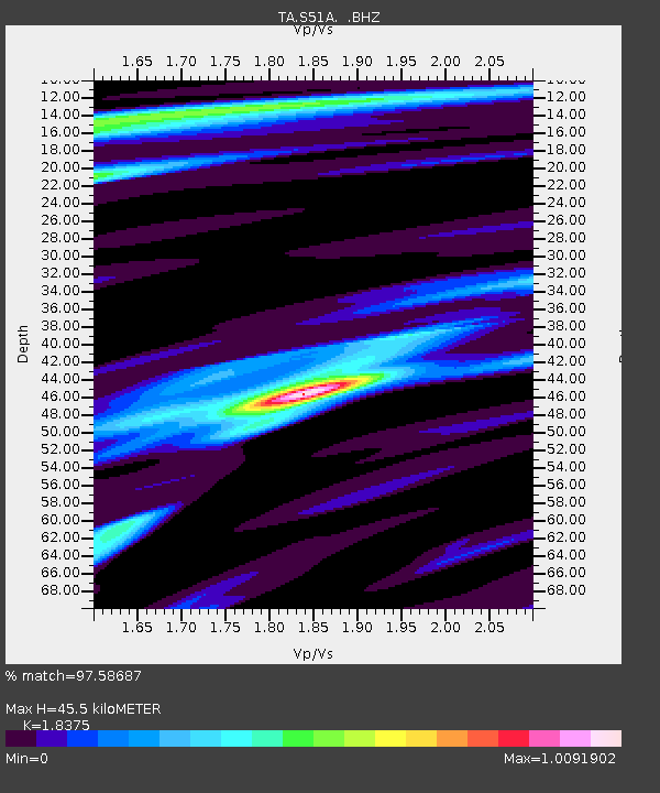
| Estimated Moho Depth: |
45.5 km |
| Estimated Crust Vp/Vs: |
1.84 |
| Assumed Crust Vp: |
6.476 km/s |
| Estimated Crust Vs: |
3.524 km/s |
| Estimated Crust Poisson's Ratio: |
0.29 |
|
| Radial Match: |
97.58687 % |
| Radial Bump: |
351 |
| Transverse Match: |
91.52755 % |
| Transverse Bump: |
359 |
| SOD ConfigId: |
626651 |
| Insert Time: |
2014-04-18 20:46:34.208 +0000 |
| GWidth: |
2.5 |
| Max Bumps: |
400 |
| Tol: |
0.001 |
|
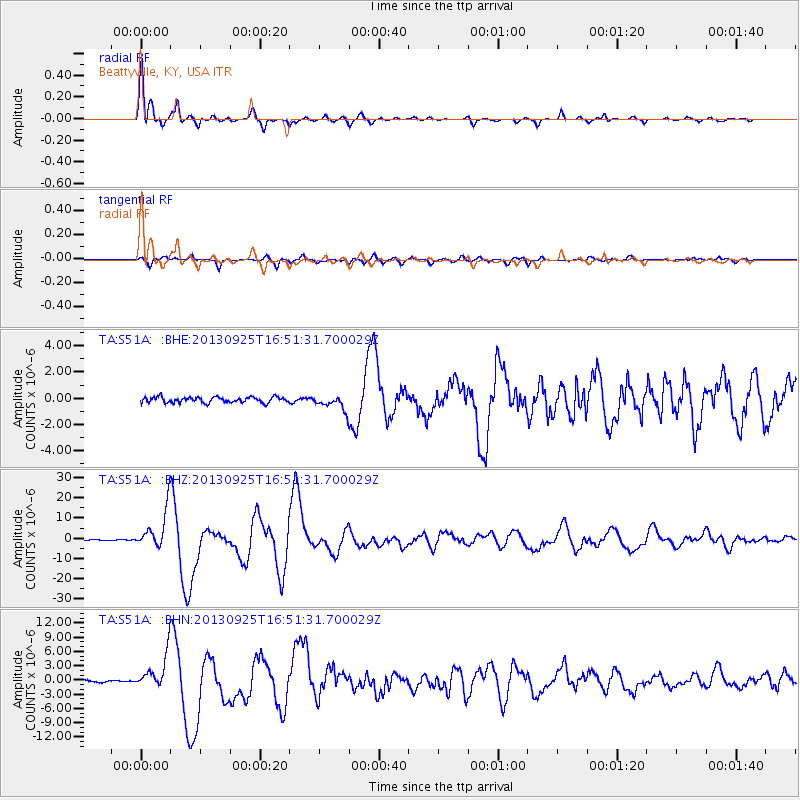
Signal To Noise
| Channel | StoN | STA | LTA |
| TA:S51A: :BHZ:20130925T16:51:31.700029Z | 39.20422 | 9.6857575E-6 | 2.4705906E-7 |
| TA:S51A: :BHN:20130925T16:51:31.700029Z | 16.749334 | 3.592976E-6 | 2.1451457E-7 |
| TA:S51A: :BHE:20130925T16:51:31.700029Z | 2.7484734 | 5.6460084E-7 | 2.0542343E-7 |
| Arrivals |
| Ps | 6.2 SECOND |
| PpPs | 19 SECOND |
| PsPs/PpSs | 25 SECOND |


