You are here: Home > Network List > TA - USArray Transportable Network (new EarthScope stations) Stations List
> Station S54A Dingess, Beckley, WV, USA > Earthquake Result Viewer
S54A Dingess, Beckley, WV, USA - Earthquake Result Viewer
| Earthquake location: |
Near Coast Of Peru |
| Earthquake latitude/longitude: |
-15.8/-74.5 |
| Earthquake time(UTC): |
2013/09/25 (268) 16:42:43 GMT |
| Earthquake Depth: |
40 km |
| Earthquake Magnitude: |
7.1 MWW, 6.8 MI, 7.0 MWB, 7.0 MWC, 7.1 MWW, 7.1 MWC |
| Earthquake Catalog/Contributor: |
NEIC PDE/NEIC COMCAT |
|
| Network: |
TA USArray Transportable Network (new EarthScope stations) |
| Station: |
S54A Dingess, Beckley, WV, USA |
| Lat/Lon: |
37.80 N/81.31 W |
| Elevation: |
636 m |
|
| Distance: |
53.7 deg |
| Az: |
353.319 deg |
| Baz: |
171.874 deg |
| Ray Param: |
0.06581465 |
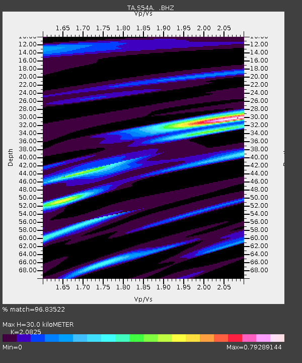
| Estimated Moho Depth: |
30.0 km |
| Estimated Crust Vp/Vs: |
2.08 |
| Assumed Crust Vp: |
6.159 km/s |
| Estimated Crust Vs: |
2.957 km/s |
| Estimated Crust Poisson's Ratio: |
0.35 |
|
| Radial Match: |
96.83522 % |
| Radial Bump: |
274 |
| Transverse Match: |
82.334076 % |
| Transverse Bump: |
372 |
| SOD ConfigId: |
626651 |
| Insert Time: |
2014-04-18 20:46:43.152 +0000 |
| GWidth: |
2.5 |
| Max Bumps: |
400 |
| Tol: |
0.001 |
|
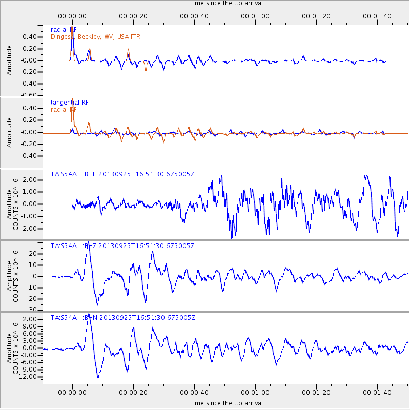
Signal To Noise
| Channel | StoN | STA | LTA |
| TA:S54A: :BHZ:20130925T16:51:30.675005Z | 33.941772 | 7.2902358E-6 | 2.1478652E-7 |
| TA:S54A: :BHN:20130925T16:51:30.675005Z | 11.673 | 2.748829E-6 | 2.3548607E-7 |
| TA:S54A: :BHE:20130925T16:51:30.675005Z | 0.8708584 | 2.0805349E-7 | 2.3890624E-7 |
| Arrivals |
| Ps | 5.5 SECOND |
| PpPs | 14 SECOND |
| PsPs/PpSs | 20 SECOND |


