You are here: Home > Network List > TA - USArray Transportable Network (new EarthScope stations) Stations List
> Station T52A Hallie, KY, USA > Earthquake Result Viewer
T52A Hallie, KY, USA - Earthquake Result Viewer
| Earthquake location: |
Near Coast Of Peru |
| Earthquake latitude/longitude: |
-15.8/-74.5 |
| Earthquake time(UTC): |
2013/09/25 (268) 16:42:43 GMT |
| Earthquake Depth: |
40 km |
| Earthquake Magnitude: |
7.1 MWW, 6.8 MI, 7.0 MWB, 7.0 MWC, 7.1 MWW, 7.1 MWC |
| Earthquake Catalog/Contributor: |
NEIC PDE/NEIC COMCAT |
|
| Network: |
TA USArray Transportable Network (new EarthScope stations) |
| Station: |
T52A Hallie, KY, USA |
| Lat/Lon: |
37.11 N/82.99 W |
| Elevation: |
436 m |
|
| Distance: |
53.3 deg |
| Az: |
351.547 deg |
| Baz: |
169.806 deg |
| Ray Param: |
0.06612929 |
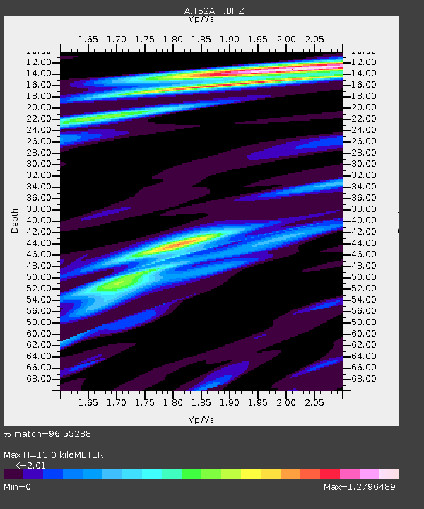
| Estimated Moho Depth: |
13.0 km |
| Estimated Crust Vp/Vs: |
2.01 |
| Assumed Crust Vp: |
6.476 km/s |
| Estimated Crust Vs: |
3.222 km/s |
| Estimated Crust Poisson's Ratio: |
0.34 |
|
| Radial Match: |
96.55288 % |
| Radial Bump: |
400 |
| Transverse Match: |
91.88687 % |
| Transverse Bump: |
400 |
| SOD ConfigId: |
626651 |
| Insert Time: |
2014-04-18 20:47:26.966 +0000 |
| GWidth: |
2.5 |
| Max Bumps: |
400 |
| Tol: |
0.001 |
|
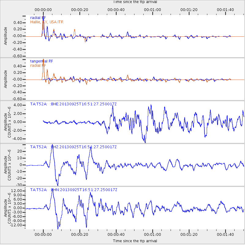
Signal To Noise
| Channel | StoN | STA | LTA |
| TA:T52A: :BHZ:20130925T16:51:27.250017Z | 25.811909 | 9.246537E-6 | 3.5822757E-7 |
| TA:T52A: :BHN:20130925T16:51:27.250017Z | 17.263918 | 3.832415E-6 | 2.2198986E-7 |
| TA:T52A: :BHE:20130925T16:51:27.250017Z | 3.3774204 | 6.210953E-7 | 1.8389633E-7 |
| Arrivals |
| Ps | 2.1 SECOND |
| PpPs | 5.8 SECOND |
| PsPs/PpSs | 7.9 SECOND |


