You are here: Home > Network List > TA - USArray Transportable Network (new EarthScope stations) Stations List
> Station T55A Pulaski, VA, USA > Earthquake Result Viewer
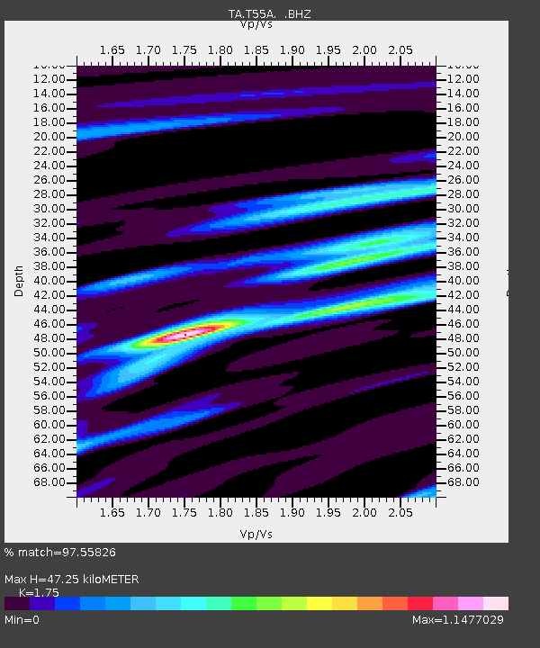
T55A Pulaski, VA, USA - Earthquake Result Viewer
| Earthquake location: |
Near Coast Of Peru |
| Earthquake latitude/longitude: |
-15.8/-74.5 |
| Earthquake time(UTC): |
2013/09/25 (268) 16:42:43 GMT |
| Earthquake Depth: |
40 km |
| Earthquake Magnitude: |
7.1 MWW, 6.8 MI, 7.0 MWB, 7.0 MWC, 7.1 MWW, 7.1 MWC |
| Earthquake Catalog/Contributor: |
NEIC PDE/NEIC COMCAT |
|
| Network: |
TA USArray Transportable Network (new EarthScope stations) |
| Station: |
T55A Pulaski, VA, USA |
| Lat/Lon: |
37.12 N/80.78 W |
| Elevation: |
644 m |
|
| Distance: |
53.0 deg |
| Az: |
353.721 deg |
| Baz: |
172.433 deg |
| Ray Param: |
0.06630493 |
| Estimated Moho Depth: |
47.25 km |
| Estimated Crust Vp/Vs: |
1.75 |
| Assumed Crust Vp: |
6.159 km/s |
| Estimated Crust Vs: |
3.519 km/s |
| Estimated Crust Poisson's Ratio: |
0.26 |
|
| Radial Match: |
97.55826 % |
| Radial Bump: |
301 |
| Transverse Match: |
92.01233 % |
| Transverse Bump: |
400 |
| SOD ConfigId: |
626651 |
| Insert Time: |
2014-04-18 20:47:37.436 +0000 |
| GWidth: |
2.5 |
| Max Bumps: |
400 |
| Tol: |
0.001 |
|

Signal To Noise
| Channel | StoN | STA | LTA |
| TA:T55A: :BHZ:20130925T16:51:25.325029Z | 22.97596 | 4.2787638E-6 | 1.8622787E-7 |
| TA:T55A: :BHN:20130925T16:51:25.325029Z | 10.521085 | 1.8600753E-6 | 1.7679501E-7 |
| TA:T55A: :BHE:20130925T16:51:25.325029Z | 3.4739919 | 7.082334E-7 | 2.0386733E-7 |
| Arrivals |
| Ps | 6.1 SECOND |
| PpPs | 20 SECOND |
| PsPs/PpSs | 26 SECOND |


