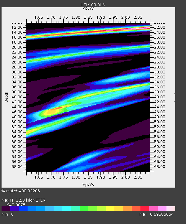
TLY Talaya, Russia - Earthquake Result Viewer

Earthquake location: New Britain Region, P.N.G.
Earthquake latitude/longitude: -5.9/150.2
Earthquake time(UTC): 2001/10/31 (304) 09:10:20 GMT
Earthquake Depth: 33 km
Earthquake Magnitude: 5.9 MB, 6.9 MS, 6.9 MW, 6.9 MW
Earthquake Catalog/Contributor: WHDF/NEIC
Network: II Global Seismograph Network (GSN - IRIS/IDA)
Station: TLY Talaya, Russia
Lat/Lon: 51.68 N/103.64 E
Elevation: 579 m
Distance: 69.8 deg
Az: 331.201 deg
Baz: 129.674 deg
Ray Param: 0.05537776
Estimated Moho Depth: 12.0 km
Estimated Crust Vp/Vs: 2.09
Assumed Crust Vp: 6.419 km/s
Estimated Crust Vs: 3.075 km/s
Estimated Crust Poisson's Ratio: 0.35
Radial Match: 98.33285 %
Radial Bump: 260
Transverse Match: 91.89327 %
Transverse Bump: 400
SOD ConfigId: 20082
Insert Time: 2010-03-01 16:58:59.722 +0000
GWidth: 2.5
Max Bumps: 400
Tol: 0.001

Signal To Noise

ChannelStoNSTALTA
II:TLY:00:BHN:20011031T09:20:55.953003Z5.8227381.824256E-73.1329865E-8
II:TLY:00:BHE:20011031T09:20:55.953003Z5.93993662.0715657E-73.4875217E-8
II:TLY:00:BHZ:20011031T09:20:55.953003Z11.0011297.410375E-76.736013E-8
Arrivals
Ps2.1 SECOND
PpPs5.6 SECOND
PsPs/PpSs7.7 SECOND