You are here: Home > Network List > TA - USArray Transportable Network (new EarthScope stations) Stations List
> Station U49A Red Boiling Springs, TN, USA > Earthquake Result Viewer
U49A Red Boiling Springs, TN, USA - Earthquake Result Viewer
| Earthquake location: |
Near Coast Of Peru |
| Earthquake latitude/longitude: |
-15.8/-74.5 |
| Earthquake time(UTC): |
2013/09/25 (268) 16:42:43 GMT |
| Earthquake Depth: |
40 km |
| Earthquake Magnitude: |
7.1 MWW, 6.8 MI, 7.0 MWB, 7.0 MWC, 7.1 MWW, 7.1 MWC |
| Earthquake Catalog/Contributor: |
NEIC PDE/NEIC COMCAT |
|
| Network: |
TA USArray Transportable Network (new EarthScope stations) |
| Station: |
U49A Red Boiling Springs, TN, USA |
| Lat/Lon: |
36.51 N/85.78 W |
| Elevation: |
234 m |
|
| Distance: |
53.1 deg |
| Az: |
348.653 deg |
| Baz: |
166.405 deg |
| Ray Param: |
0.06620861 |
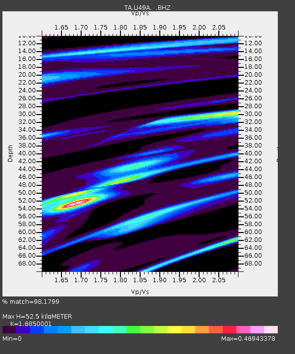
| Estimated Moho Depth: |
52.5 km |
| Estimated Crust Vp/Vs: |
1.69 |
| Assumed Crust Vp: |
6.476 km/s |
| Estimated Crust Vs: |
3.843 km/s |
| Estimated Crust Poisson's Ratio: |
0.23 |
|
| Radial Match: |
98.1799 % |
| Radial Bump: |
136 |
| Transverse Match: |
92.92438 % |
| Transverse Bump: |
298 |
| SOD ConfigId: |
626651 |
| Insert Time: |
2014-04-18 20:48:46.752 +0000 |
| GWidth: |
2.5 |
| Max Bumps: |
400 |
| Tol: |
0.001 |
|

Signal To Noise
| Channel | StoN | STA | LTA |
| TA:U49A: :BHZ:20130925T16:51:26.373979Z | 99.674286 | 1.08538725E-5 | 1.088934E-7 |
| TA:U49A: :BHN:20130925T16:51:26.373979Z | 52.050594 | 5.2715304E-6 | 1.0127705E-7 |
| TA:U49A: :BHE:20130925T16:51:26.373979Z | 8.892503 | 1.0574768E-6 | 1.1891778E-7 |
| Arrivals |
| Ps | 5.9 SECOND |
| PpPs | 21 SECOND |
| PsPs/PpSs | 26 SECOND |


