You are here: Home > Network List > TA - USArray Transportable Network (new EarthScope stations) Stations List
> Station U52A Thorn Hill, TN, USA > Earthquake Result Viewer
U52A Thorn Hill, TN, USA - Earthquake Result Viewer
| Earthquake location: |
Near Coast Of Peru |
| Earthquake latitude/longitude: |
-15.8/-74.5 |
| Earthquake time(UTC): |
2013/09/25 (268) 16:42:43 GMT |
| Earthquake Depth: |
40 km |
| Earthquake Magnitude: |
7.1 MWW, 6.8 MI, 7.0 MWB, 7.0 MWC, 7.1 MWW, 7.1 MWC |
| Earthquake Catalog/Contributor: |
NEIC PDE/NEIC COMCAT |
|
| Network: |
TA USArray Transportable Network (new EarthScope stations) |
| Station: |
U52A Thorn Hill, TN, USA |
| Lat/Lon: |
36.39 N/83.37 W |
| Elevation: |
510 m |
|
| Distance: |
52.6 deg |
| Az: |
351.006 deg |
| Baz: |
169.252 deg |
| Ray Param: |
0.06656005 |
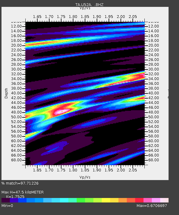
| Estimated Moho Depth: |
47.5 km |
| Estimated Crust Vp/Vs: |
1.75 |
| Assumed Crust Vp: |
6.476 km/s |
| Estimated Crust Vs: |
3.695 km/s |
| Estimated Crust Poisson's Ratio: |
0.26 |
|
| Radial Match: |
97.71226 % |
| Radial Bump: |
218 |
| Transverse Match: |
95.1689 % |
| Transverse Bump: |
400 |
| SOD ConfigId: |
626651 |
| Insert Time: |
2014-04-18 20:49:00.955 +0000 |
| GWidth: |
2.5 |
| Max Bumps: |
400 |
| Tol: |
0.001 |
|
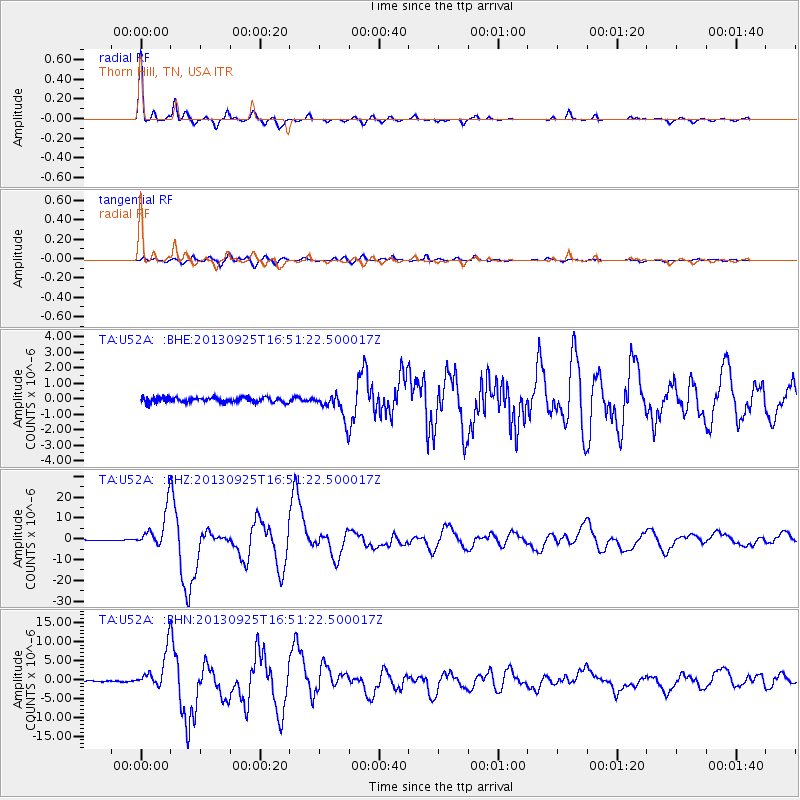
Signal To Noise
| Channel | StoN | STA | LTA |
| TA:U52A: :BHZ:20130925T16:51:22.500017Z | 49.906155 | 9.033425E-6 | 1.8100823E-7 |
| TA:U52A: :BHN:20130925T16:51:22.500017Z | 23.47447 | 4.894904E-6 | 2.0852033E-7 |
| TA:U52A: :BHE:20130925T16:51:22.500017Z | 5.0134225 | 8.1192024E-7 | 1.619493E-7 |
| Arrivals |
| Ps | 5.8 SECOND |
| PpPs | 19 SECOND |
| PsPs/PpSs | 25 SECOND |


