You are here: Home > Network List > TA - USArray Transportable Network (new EarthScope stations) Stations List
> Station V52A Sevierville, TN, USA > Earthquake Result Viewer
V52A Sevierville, TN, USA - Earthquake Result Viewer
| Earthquake location: |
Near Coast Of Peru |
| Earthquake latitude/longitude: |
-15.8/-74.5 |
| Earthquake time(UTC): |
2013/09/25 (268) 16:42:43 GMT |
| Earthquake Depth: |
40 km |
| Earthquake Magnitude: |
7.1 MWW, 6.8 MI, 7.0 MWB, 7.0 MWC, 7.1 MWW, 7.1 MWC |
| Earthquake Catalog/Contributor: |
NEIC PDE/NEIC COMCAT |
|
| Network: |
TA USArray Transportable Network (new EarthScope stations) |
| Station: |
V52A Sevierville, TN, USA |
| Lat/Lon: |
35.84 N/83.60 W |
| Elevation: |
328 m |
|
| Distance: |
52.1 deg |
| Az: |
350.645 deg |
| Baz: |
168.898 deg |
| Ray Param: |
0.06688259 |
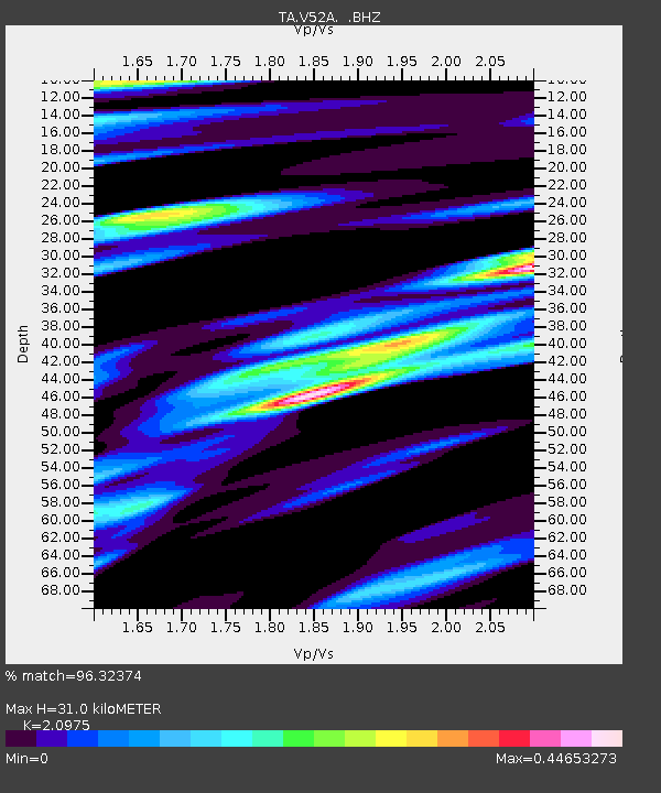
| Estimated Moho Depth: |
31.0 km |
| Estimated Crust Vp/Vs: |
2.10 |
| Assumed Crust Vp: |
6.35 km/s |
| Estimated Crust Vs: |
3.027 km/s |
| Estimated Crust Poisson's Ratio: |
0.35 |
|
| Radial Match: |
96.32374 % |
| Radial Bump: |
400 |
| Transverse Match: |
94.35906 % |
| Transverse Bump: |
400 |
| SOD ConfigId: |
626651 |
| Insert Time: |
2014-04-18 20:49:38.776 +0000 |
| GWidth: |
2.5 |
| Max Bumps: |
400 |
| Tol: |
0.001 |
|

Signal To Noise
| Channel | StoN | STA | LTA |
| TA:V52A: :BHZ:20130925T16:51:18.77498Z | 50.03623 | 1.0733229E-5 | 2.1450916E-7 |
| TA:V52A: :BHN:20130925T16:51:18.77498Z | 21.534182 | 4.88529E-6 | 2.2686211E-7 |
| TA:V52A: :BHE:20130925T16:51:18.77498Z | 4.547289 | 9.546528E-7 | 2.099389E-7 |
| Arrivals |
| Ps | 5.6 SECOND |
| PpPs | 14 SECOND |
| PsPs/PpSs | 20 SECOND |


