You are here: Home > Network List > TA - USArray Transportable Network (new EarthScope stations) Stations List
> Station V53A Saluda, NC, USA > Earthquake Result Viewer
V53A Saluda, NC, USA - Earthquake Result Viewer
| Earthquake location: |
Near Coast Of Peru |
| Earthquake latitude/longitude: |
-15.8/-74.5 |
| Earthquake time(UTC): |
2013/09/25 (268) 16:42:43 GMT |
| Earthquake Depth: |
40 km |
| Earthquake Magnitude: |
7.1 MWW, 6.8 MI, 7.0 MWB, 7.0 MWC, 7.1 MWW, 7.1 MWC |
| Earthquake Catalog/Contributor: |
NEIC PDE/NEIC COMCAT |
|
| Network: |
TA USArray Transportable Network (new EarthScope stations) |
| Station: |
V53A Saluda, NC, USA |
| Lat/Lon: |
35.67 N/82.81 W |
| Elevation: |
681 m |
|
| Distance: |
51.8 deg |
| Az: |
351.4 deg |
| Baz: |
169.818 deg |
| Ray Param: |
0.06706995 |
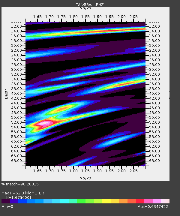
| Estimated Moho Depth: |
52.0 km |
| Estimated Crust Vp/Vs: |
1.68 |
| Assumed Crust Vp: |
6.35 km/s |
| Estimated Crust Vs: |
3.791 km/s |
| Estimated Crust Poisson's Ratio: |
0.22 |
|
| Radial Match: |
98.20315 % |
| Radial Bump: |
259 |
| Transverse Match: |
91.00544 % |
| Transverse Bump: |
400 |
| SOD ConfigId: |
626651 |
| Insert Time: |
2014-04-18 20:49:43.857 +0000 |
| GWidth: |
2.5 |
| Max Bumps: |
400 |
| Tol: |
0.001 |
|

Signal To Noise
| Channel | StoN | STA | LTA |
| TA:V53A: :BHZ:20130925T16:51:16.625017Z | 31.927734 | 5.290113E-6 | 1.6569021E-7 |
| TA:V53A: :BHN:20130925T16:51:16.625017Z | 16.60323 | 2.5646596E-6 | 1.5446751E-7 |
| TA:V53A: :BHE:20130925T16:51:16.625017Z | 1.9452465 | 3.728807E-7 | 1.9168814E-7 |
| Arrivals |
| Ps | 5.9 SECOND |
| PpPs | 21 SECOND |
| PsPs/PpSs | 27 SECOND |


