You are here: Home > Network List > TA - USArray Transportable Network (new EarthScope stations) Stations List
> Station V62A Hyde County Airport, Englehard, NC, USA > Earthquake Result Viewer
V62A Hyde County Airport, Englehard, NC, USA - Earthquake Result Viewer
| Earthquake location: |
Near Coast Of Peru |
| Earthquake latitude/longitude: |
-15.8/-74.5 |
| Earthquake time(UTC): |
2013/09/25 (268) 16:42:43 GMT |
| Earthquake Depth: |
40 km |
| Earthquake Magnitude: |
7.1 MWW, 6.8 MI, 7.0 MWB, 7.0 MWC, 7.1 MWW, 7.1 MWC |
| Earthquake Catalog/Contributor: |
NEIC PDE/NEIC COMCAT |
|
| Network: |
TA USArray Transportable Network (new EarthScope stations) |
| Station: |
V62A Hyde County Airport, Englehard, NC, USA |
| Lat/Lon: |
35.56 N/75.96 W |
| Elevation: |
-3.0 m |
|
| Distance: |
51.1 deg |
| Az: |
358.486 deg |
| Baz: |
178.213 deg |
| Ray Param: |
0.067519456 |
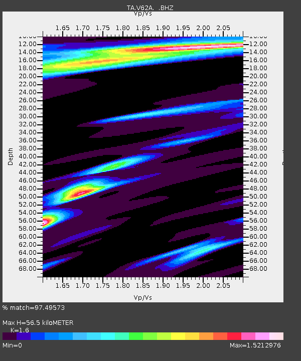
| Estimated Moho Depth: |
56.5 km |
| Estimated Crust Vp/Vs: |
1.60 |
| Assumed Crust Vp: |
5.738 km/s |
| Estimated Crust Vs: |
3.586 km/s |
| Estimated Crust Poisson's Ratio: |
0.18 |
|
| Radial Match: |
97.49573 % |
| Radial Bump: |
270 |
| Transverse Match: |
89.31844 % |
| Transverse Bump: |
242 |
| SOD ConfigId: |
626651 |
| Insert Time: |
2014-04-18 20:50:06.560 +0000 |
| GWidth: |
2.5 |
| Max Bumps: |
400 |
| Tol: |
0.001 |
|
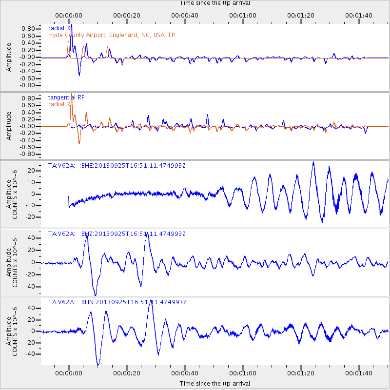
Signal To Noise
| Channel | StoN | STA | LTA |
| TA:V62A: :BHZ:20130925T16:51:11.474993Z | 6.8020363 | 4.036111E-6 | 5.9336804E-7 |
| TA:V62A: :BHN:20130925T16:51:11.474993Z | 2.5182807 | 3.4960792E-6 | 1.3882801E-6 |
| TA:V62A: :BHE:20130925T16:51:11.474993Z | 0.8504764 | 2.8738457E-6 | 3.3791011E-6 |
| Arrivals |
| Ps | 6.2 SECOND |
| PpPs | 24 SECOND |
| PsPs/PpSs | 31 SECOND |


