You are here: Home > Network List > TA - USArray Transportable Network (new EarthScope stations) Stations List
> Station W54A Cherokee Point, Campobello, SC, USA > Earthquake Result Viewer
W54A Cherokee Point, Campobello, SC, USA - Earthquake Result Viewer
| Earthquake location: |
Near Coast Of Peru |
| Earthquake latitude/longitude: |
-15.8/-74.5 |
| Earthquake time(UTC): |
2013/09/25 (268) 16:42:43 GMT |
| Earthquake Depth: |
40 km |
| Earthquake Magnitude: |
7.1 MWW, 6.8 MI, 7.0 MWB, 7.0 MWC, 7.1 MWW, 7.1 MWC |
| Earthquake Catalog/Contributor: |
NEIC PDE/NEIC COMCAT |
|
| Network: |
TA USArray Transportable Network (new EarthScope stations) |
| Station: |
W54A Cherokee Point, Campobello, SC, USA |
| Lat/Lon: |
35.09 N/82.19 W |
| Elevation: |
272 m |
|
| Distance: |
51.2 deg |
| Az: |
351.917 deg |
| Baz: |
170.502 deg |
| Ray Param: |
0.06750128 |
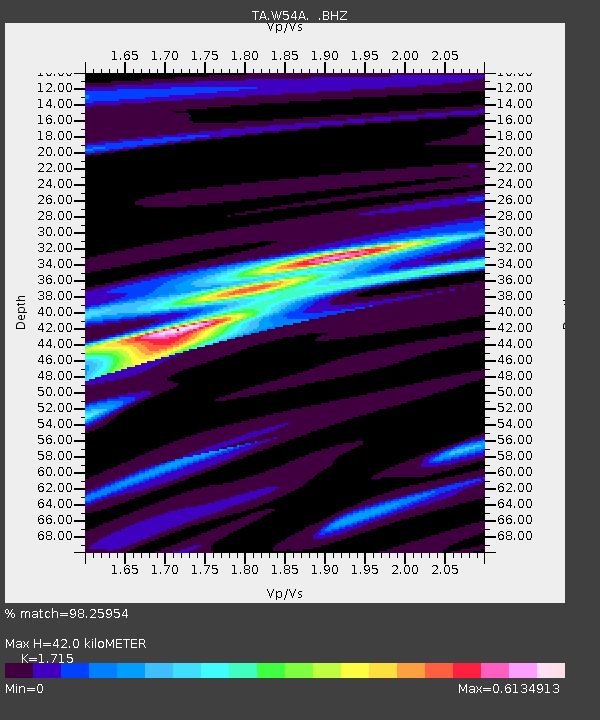
| Estimated Moho Depth: |
42.0 km |
| Estimated Crust Vp/Vs: |
1.72 |
| Assumed Crust Vp: |
6.35 km/s |
| Estimated Crust Vs: |
3.703 km/s |
| Estimated Crust Poisson's Ratio: |
0.24 |
|
| Radial Match: |
98.25954 % |
| Radial Bump: |
183 |
| Transverse Match: |
90.43931 % |
| Transverse Bump: |
400 |
| SOD ConfigId: |
626651 |
| Insert Time: |
2014-04-18 20:50:30.611 +0000 |
| GWidth: |
2.5 |
| Max Bumps: |
400 |
| Tol: |
0.001 |
|

Signal To Noise
| Channel | StoN | STA | LTA |
| TA:W54A: :BHZ:20130925T16:51:11.699999Z | 23.04859 | 4.465878E-6 | 1.9375929E-7 |
| TA:W54A: :BHN:20130925T16:51:11.699999Z | 15.326974 | 2.2895904E-6 | 1.4938306E-7 |
| TA:W54A: :BHE:20130925T16:51:11.699999Z | 5.5367985 | 5.087806E-7 | 9.1890755E-8 |
| Arrivals |
| Ps | 5.0 SECOND |
| PpPs | 17 SECOND |
| PsPs/PpSs | 22 SECOND |


