You are here: Home > Network List > TA - USArray Transportable Network (new EarthScope stations) Stations List
> Station X56A White Oak, SC, USA > Earthquake Result Viewer
X56A White Oak, SC, USA - Earthquake Result Viewer
| Earthquake location: |
Near Coast Of Peru |
| Earthquake latitude/longitude: |
-15.8/-74.5 |
| Earthquake time(UTC): |
2013/09/25 (268) 16:42:43 GMT |
| Earthquake Depth: |
40 km |
| Earthquake Magnitude: |
7.1 MWW, 6.8 MI, 7.0 MWB, 7.0 MWC, 7.1 MWW, 7.1 MWC |
| Earthquake Catalog/Contributor: |
NEIC PDE/NEIC COMCAT |
|
| Network: |
TA USArray Transportable Network (new EarthScope stations) |
| Station: |
X56A White Oak, SC, USA |
| Lat/Lon: |
34.49 N/81.03 W |
| Elevation: |
112 m |
|
| Distance: |
50.4 deg |
| Az: |
353.011 deg |
| Baz: |
171.849 deg |
| Ray Param: |
0.06796865 |
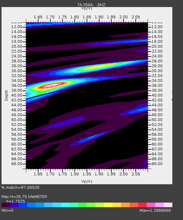
| Estimated Moho Depth: |
35.75 km |
| Estimated Crust Vp/Vs: |
1.70 |
| Assumed Crust Vp: |
6.419 km/s |
| Estimated Crust Vs: |
3.77 km/s |
| Estimated Crust Poisson's Ratio: |
0.24 |
|
| Radial Match: |
97.88028 % |
| Radial Bump: |
172 |
| Transverse Match: |
87.086975 % |
| Transverse Bump: |
400 |
| SOD ConfigId: |
626651 |
| Insert Time: |
2014-04-18 20:51:03.711 +0000 |
| GWidth: |
2.5 |
| Max Bumps: |
400 |
| Tol: |
0.001 |
|

Signal To Noise
| Channel | StoN | STA | LTA |
| TA:X56A: :BHZ:20130925T16:51:06.223986Z | 39.29621 | 5.561607E-6 | 1.4153035E-7 |
| TA:X56A: :BHN:20130925T16:51:06.223986Z | 22.422564 | 2.8422803E-6 | 1.2675983E-7 |
| TA:X56A: :BHE:20130925T16:51:06.223986Z | 4.2648597 | 5.72742E-7 | 1.3429327E-7 |
| Arrivals |
| Ps | 4.2 SECOND |
| PpPs | 14 SECOND |
| PsPs/PpSs | 18 SECOND |


