You are here: Home > Network List > TA - USArray Transportable Network (new EarthScope stations) Stations List
> Station X59A McDuffie Farm, Elizabethtown, NC, USA > Earthquake Result Viewer
X59A McDuffie Farm, Elizabethtown, NC, USA - Earthquake Result Viewer
| Earthquake location: |
Near Coast Of Peru |
| Earthquake latitude/longitude: |
-15.8/-74.5 |
| Earthquake time(UTC): |
2013/09/25 (268) 16:42:43 GMT |
| Earthquake Depth: |
40 km |
| Earthquake Magnitude: |
7.1 MWW, 6.8 MI, 7.0 MWB, 7.0 MWC, 7.1 MWW, 7.1 MWC |
| Earthquake Catalog/Contributor: |
NEIC PDE/NEIC COMCAT |
|
| Network: |
TA USArray Transportable Network (new EarthScope stations) |
| Station: |
X59A McDuffie Farm, Elizabethtown, NC, USA |
| Lat/Lon: |
34.57 N/78.60 W |
| Elevation: |
29 m |
|
| Distance: |
50.3 deg |
| Az: |
355.61 deg |
| Baz: |
174.878 deg |
| Ray Param: |
0.068071716 |
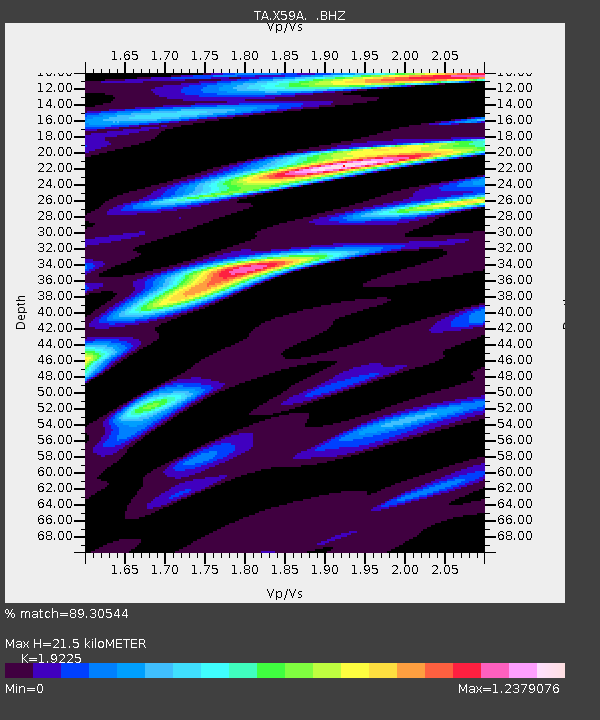
| Estimated Moho Depth: |
21.5 km |
| Estimated Crust Vp/Vs: |
1.92 |
| Assumed Crust Vp: |
6.565 km/s |
| Estimated Crust Vs: |
3.415 km/s |
| Estimated Crust Poisson's Ratio: |
0.31 |
|
| Radial Match: |
89.30544 % |
| Radial Bump: |
400 |
| Transverse Match: |
74.64482 % |
| Transverse Bump: |
400 |
| SOD ConfigId: |
626651 |
| Insert Time: |
2014-04-18 20:51:10.939 +0000 |
| GWidth: |
2.5 |
| Max Bumps: |
400 |
| Tol: |
0.001 |
|
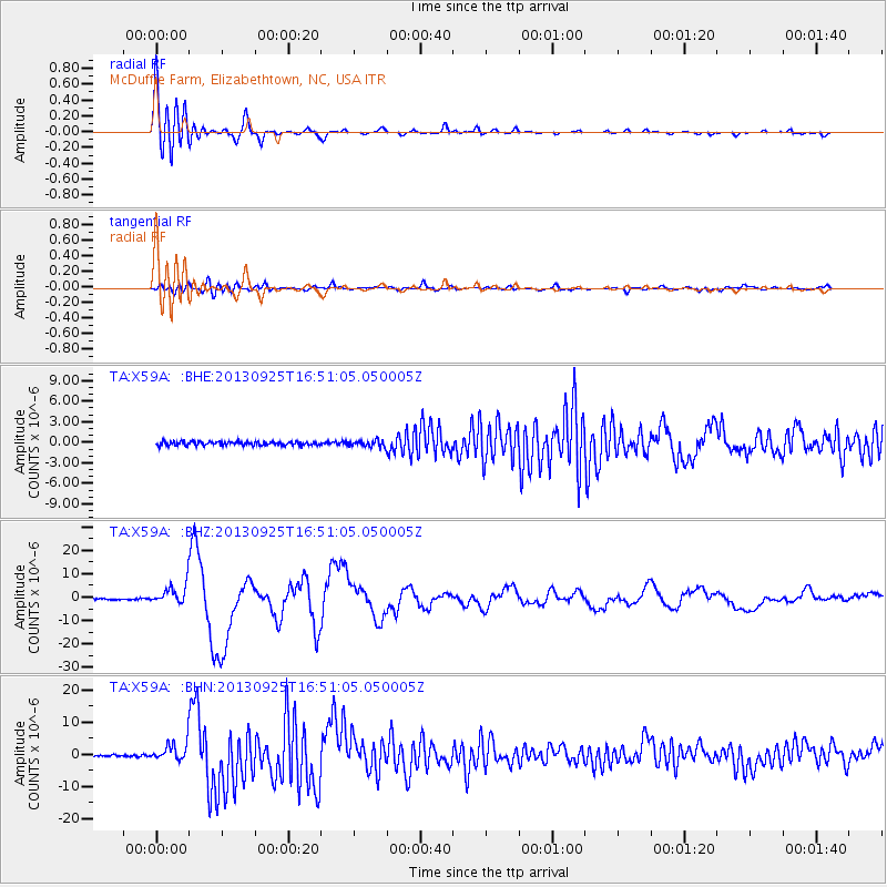
Signal To Noise
| Channel | StoN | STA | LTA |
| TA:X59A: :BHZ:20130925T16:51:05.050005Z | 22.162718 | 4.326517E-6 | 1.95216E-7 |
| TA:X59A: :BHN:20130925T16:51:05.050005Z | 9.565485 | 2.7385659E-6 | 2.8629663E-7 |
| TA:X59A: :BHE:20130925T16:51:05.050005Z | 1.6898829 | 4.604209E-7 | 2.7245727E-7 |
| Arrivals |
| Ps | 3.2 SECOND |
| PpPs | 9.1 SECOND |
| PsPs/PpSs | 12 SECOND |


