You are here: Home > Network List > TA - USArray Transportable Network (new EarthScope stations) Stations List
> Station Y52A Lilburn, GA, USA > Earthquake Result Viewer
Y52A Lilburn, GA, USA - Earthquake Result Viewer
| Earthquake location: |
Near Coast Of Peru |
| Earthquake latitude/longitude: |
-15.8/-74.5 |
| Earthquake time(UTC): |
2013/09/25 (268) 16:42:43 GMT |
| Earthquake Depth: |
40 km |
| Earthquake Magnitude: |
7.1 MWW, 6.8 MI, 7.0 MWB, 7.0 MWC, 7.1 MWW, 7.1 MWC |
| Earthquake Catalog/Contributor: |
NEIC PDE/NEIC COMCAT |
|
| Network: |
TA USArray Transportable Network (new EarthScope stations) |
| Station: |
Y52A Lilburn, GA, USA |
| Lat/Lon: |
33.86 N/84.06 W |
| Elevation: |
286 m |
|
| Distance: |
50.3 deg |
| Az: |
349.656 deg |
| Baz: |
168.012 deg |
| Ray Param: |
0.068088315 |
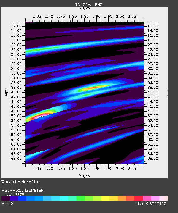
| Estimated Moho Depth: |
50.0 km |
| Estimated Crust Vp/Vs: |
1.67 |
| Assumed Crust Vp: |
6.719 km/s |
| Estimated Crust Vs: |
4.03 km/s |
| Estimated Crust Poisson's Ratio: |
0.22 |
|
| Radial Match: |
96.384155 % |
| Radial Bump: |
218 |
| Transverse Match: |
88.97048 % |
| Transverse Bump: |
400 |
| SOD ConfigId: |
626651 |
| Insert Time: |
2014-04-18 20:51:23.598 +0000 |
| GWidth: |
2.5 |
| Max Bumps: |
400 |
| Tol: |
0.001 |
|
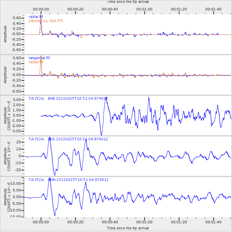
Signal To Noise
| Channel | StoN | STA | LTA |
| TA:Y52A: :BHZ:20130925T16:51:04.87401Z | 55.043556 | 8.623968E-6 | 1.5667534E-7 |
| TA:Y52A: :BHN:20130925T16:51:04.87401Z | 27.712053 | 4.508013E-6 | 1.6267336E-7 |
| TA:Y52A: :BHE:20130925T16:51:04.87401Z | 7.5065584 | 1.0258349E-6 | 1.3665847E-7 |
| Arrivals |
| Ps | 5.3 SECOND |
| PpPs | 19 SECOND |
| PsPs/PpSs | 24 SECOND |


