You are here: Home > Network List > TA - USArray Transportable Network (new EarthScope stations) Stations List
> Station Y56A Pelion, SC, USA > Earthquake Result Viewer
Y56A Pelion, SC, USA - Earthquake Result Viewer
| Earthquake location: |
Near Coast Of Peru |
| Earthquake latitude/longitude: |
-15.8/-74.5 |
| Earthquake time(UTC): |
2013/09/25 (268) 16:42:43 GMT |
| Earthquake Depth: |
40 km |
| Earthquake Magnitude: |
7.1 MWW, 6.8 MI, 7.0 MWB, 7.0 MWC, 7.1 MWW, 7.1 MWC |
| Earthquake Catalog/Contributor: |
NEIC PDE/NEIC COMCAT |
|
| Network: |
TA USArray Transportable Network (new EarthScope stations) |
| Station: |
Y56A Pelion, SC, USA |
| Lat/Lon: |
33.79 N/81.30 W |
| Elevation: |
154 m |
|
| Distance: |
49.8 deg |
| Az: |
352.587 deg |
| Baz: |
171.424 deg |
| Ray Param: |
0.06839865 |
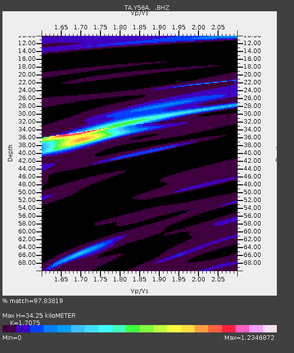
| Estimated Moho Depth: |
34.25 km |
| Estimated Crust Vp/Vs: |
1.71 |
| Assumed Crust Vp: |
6.565 km/s |
| Estimated Crust Vs: |
3.845 km/s |
| Estimated Crust Poisson's Ratio: |
0.24 |
|
| Radial Match: |
97.83819 % |
| Radial Bump: |
176 |
| Transverse Match: |
79.43207 % |
| Transverse Bump: |
400 |
| SOD ConfigId: |
626651 |
| Insert Time: |
2014-04-18 20:51:32.459 +0000 |
| GWidth: |
2.5 |
| Max Bumps: |
400 |
| Tol: |
0.001 |
|
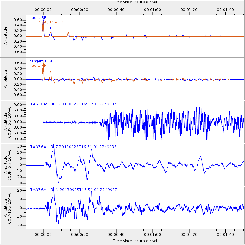
Signal To Noise
| Channel | StoN | STA | LTA |
| TA:Y56A: :BHZ:20130925T16:51:01.224993Z | 27.753132 | 5.504153E-6 | 1.9832547E-7 |
| TA:Y56A: :BHN:20130925T16:51:01.224993Z | 21.83192 | 4.337503E-6 | 1.9867713E-7 |
| TA:Y56A: :BHE:20130925T16:51:01.224993Z | 5.6924644 | 1.0469429E-6 | 1.8391734E-7 |
| Arrivals |
| Ps | 3.9 SECOND |
| PpPs | 13 SECOND |
| PsPs/PpSs | 17 SECOND |


