You are here: Home > Network List > US - United States National Seismic Network Stations List
> Station BINY Binghamton, New York, USA > Earthquake Result Viewer
BINY Binghamton, New York, USA - Earthquake Result Viewer
| Earthquake location: |
Near Coast Of Peru |
| Earthquake latitude/longitude: |
-15.8/-74.5 |
| Earthquake time(UTC): |
2013/09/25 (268) 16:42:43 GMT |
| Earthquake Depth: |
40 km |
| Earthquake Magnitude: |
7.1 MWW, 6.8 MI, 7.0 MWB, 7.0 MWC, 7.1 MWW, 7.1 MWC |
| Earthquake Catalog/Contributor: |
NEIC PDE/NEIC COMCAT |
|
| Network: |
US United States National Seismic Network |
| Station: |
BINY Binghamton, New York, USA |
| Lat/Lon: |
42.20 N/75.99 W |
| Elevation: |
498 m |
|
| Distance: |
57.8 deg |
| Az: |
358.704 deg |
| Baz: |
178.322 deg |
| Ray Param: |
0.063204594 |
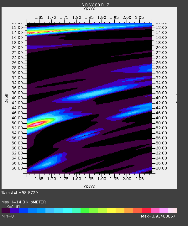
| Estimated Moho Depth: |
14.0 km |
| Estimated Crust Vp/Vs: |
1.61 |
| Assumed Crust Vp: |
6.419 km/s |
| Estimated Crust Vs: |
3.987 km/s |
| Estimated Crust Poisson's Ratio: |
0.19 |
|
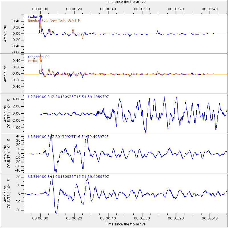
| Radial Match: |
98.8729 % |
| Radial Bump: |
168 |
| Transverse Match: |
94.51854 % |
| Transverse Bump: |
353 |
| SOD ConfigId: |
626651 |
| Insert Time: |
2014-04-18 20:52:35.997 +0000 |
| GWidth: |
2.5 |
| Max Bumps: |
400 |
| Tol: |
0.001 |
|
Signal To Noise
| Channel | StoN | STA | LTA |
| US:BINY:00:BHZ:20130925T16:51:59.498979Z | 9.486713 | 3.859801E-6 | 4.0686385E-7 |
| US:BINY:00:BH1:20130925T16:51:59.498979Z | 5.7582564 | 1.3526442E-6 | 2.3490516E-7 |
| US:BINY:00:BH2:20130925T16:51:59.498979Z | 1.1902491 | 2.821088E-7 | 2.370166E-7 |
| Arrivals |
| Ps | 1.4 SECOND |
| PpPs | 5.4 SECOND |
| PsPs/PpSs | 6.8 SECOND |


