You are here: Home > Network List > US - United States National Seismic Network Stations List
> Station DGMT Dagmar, Montana, USA > Earthquake Result Viewer
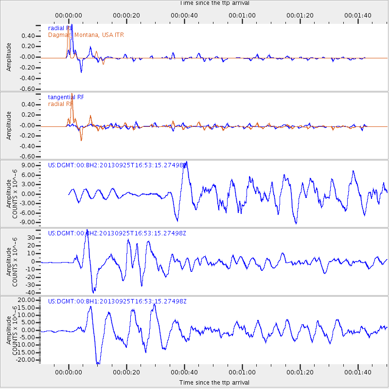
DGMT Dagmar, Montana, USA - Earthquake Result Viewer
*The percent match for this event was below the threshold and hence no stack was calculated.
| Earthquake location: |
Near Coast Of Peru |
| Earthquake latitude/longitude: |
-15.8/-74.5 |
| Earthquake time(UTC): |
2013/09/25 (268) 16:42:43 GMT |
| Earthquake Depth: |
40 km |
| Earthquake Magnitude: |
7.1 MWW, 6.8 MI, 7.0 MWB, 7.0 MWC, 7.1 MWW, 7.1 MWC |
| Earthquake Catalog/Contributor: |
NEIC PDE/NEIC COMCAT |
|
| Network: |
US United States National Seismic Network |
| Station: |
DGMT Dagmar, Montana, USA |
| Lat/Lon: |
48.47 N/104.20 W |
| Elevation: |
0.0 m |
|
| Distance: |
69.3 deg |
| Az: |
339.366 deg |
| Baz: |
149.359 deg |
| Ray Param: |
$rayparam |
*The percent match for this event was below the threshold and hence was not used in the summary stack. |
|
| Radial Match: |
98.032005 % |
| Radial Bump: |
208 |
| Transverse Match: |
90.75866 % |
| Transverse Bump: |
400 |
| SOD ConfigId: |
626651 |
| Insert Time: |
2014-04-18 20:53:01.229 +0000 |
| GWidth: |
2.5 |
| Max Bumps: |
400 |
| Tol: |
0.001 |
|
Signal To Noise
| Channel | StoN | STA | LTA |
| US:DGMT:00:BHZ:20130925T16:53:15.27498Z | 20.211271 | 3.6383312E-6 | 1.8001496E-7 |
| US:DGMT:00:BH1:20130925T16:53:15.27498Z | 2.6980217 | 1.1650488E-6 | 4.3181598E-7 |
| US:DGMT:00:BH2:20130925T16:53:15.27498Z | 0.63366205 | 6.5938497E-7 | 1.040594E-6 |
| Arrivals |
| Ps | |
| PpPs | |
| PsPs/PpSs | |


