You are here: Home > Network List > US - United States National Seismic Network Stations List
> Station EYMN Ely, Minnesota, USA > Earthquake Result Viewer
EYMN Ely, Minnesota, USA - Earthquake Result Viewer
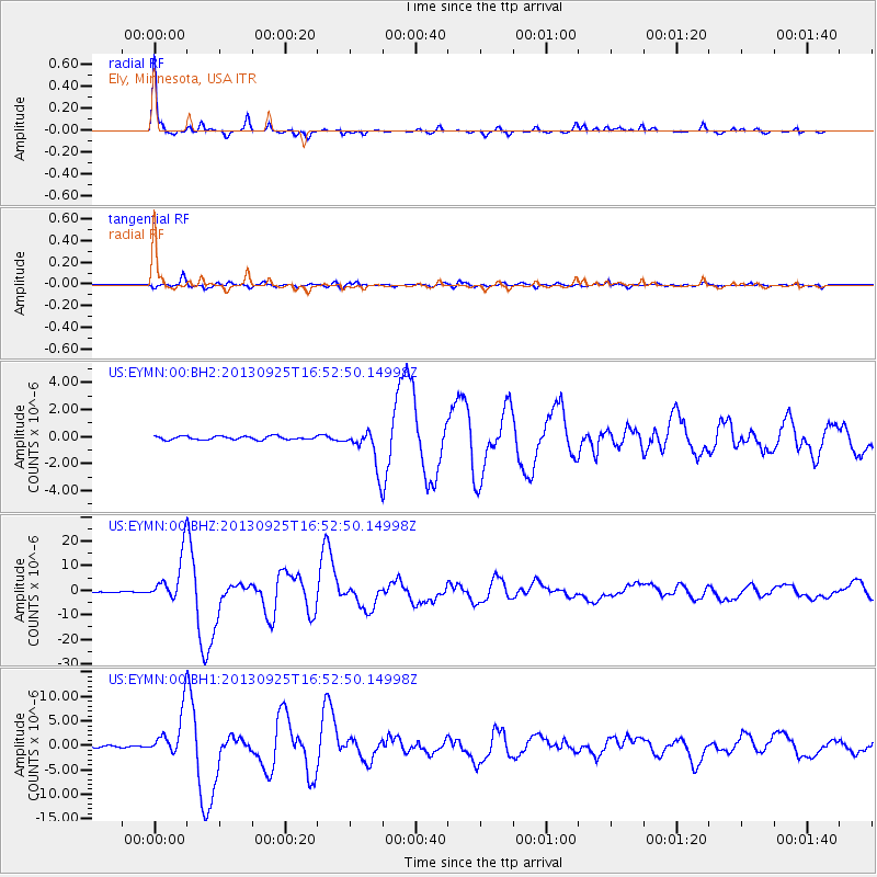
| Earthquake location: |
Near Coast Of Peru |
| Earthquake latitude/longitude: |
-15.8/-74.5 |
| Earthquake time(UTC): |
2013/09/25 (268) 16:42:43 GMT |
| Earthquake Depth: |
40 km |
| Earthquake Magnitude: |
7.1 MWW, 6.8 MI, 7.0 MWB, 7.0 MWC, 7.1 MWW, 7.1 MWC |
| Earthquake Catalog/Contributor: |
NEIC PDE/NEIC COMCAT |
|
| Network: |
US United States National Seismic Network |
| Station: |
EYMN Ely, Minnesota, USA |
| Lat/Lon: |
47.95 N/91.50 W |
| Elevation: |
475 m |
|
| Distance: |
65.3 deg |
| Az: |
347.515 deg |
| Baz: |
161.971 deg |
| Ray Param: |
0.058298063 |
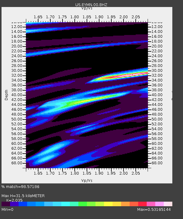
| Estimated Moho Depth: |
31.5 km |
| Estimated Crust Vp/Vs: |
2.04 |
| Assumed Crust Vp: |
6.467 km/s |
| Estimated Crust Vs: |
3.178 km/s |
| Estimated Crust Poisson's Ratio: |
0.34 |
|
| Radial Match: |
98.57186 % |
| Radial Bump: |
181 |
| Transverse Match: |
92.11213 % |
| Transverse Bump: |
400 |
| SOD ConfigId: |
626651 |
| Insert Time: |
2014-04-18 20:53:14.875 +0000 |
| GWidth: |
2.5 |
| Max Bumps: |
400 |
| Tol: |
0.001 |
|
Signal To Noise
| Channel | StoN | STA | LTA |
| US:EYMN:00:BHZ:20130925T16:52:50.14998Z | 41.942368 | 9.506126E-6 | 2.2664734E-7 |
| US:EYMN:00:BH1:20130925T16:52:50.14998Z | 34.3737 | 4.5542383E-6 | 1.3249195E-7 |
| US:EYMN:00:BH2:20130925T16:52:50.14998Z | 11.504258 | 1.4404391E-6 | 1.2520921E-7 |
| Arrivals |
| Ps | 5.2 SECOND |
| PpPs | 14 SECOND |
| PsPs/PpSs | 19 SECOND |


