You are here: Home > Network List > US - United States National Seismic Network Stations List
> Station GOGA Godfrey, Georgia, USA > Earthquake Result Viewer
GOGA Godfrey, Georgia, USA - Earthquake Result Viewer
| Earthquake location: |
Near Coast Of Peru |
| Earthquake latitude/longitude: |
-15.8/-74.5 |
| Earthquake time(UTC): |
2013/09/25 (268) 16:42:43 GMT |
| Earthquake Depth: |
40 km |
| Earthquake Magnitude: |
7.1 MWW, 6.8 MI, 7.0 MWB, 7.0 MWC, 7.1 MWW, 7.1 MWC |
| Earthquake Catalog/Contributor: |
NEIC PDE/NEIC COMCAT |
|
| Network: |
US United States National Seismic Network |
| Station: |
GOGA Godfrey, Georgia, USA |
| Lat/Lon: |
33.41 N/83.47 W |
| Elevation: |
150 m |
|
| Distance: |
49.7 deg |
| Az: |
350.172 deg |
| Baz: |
168.673 deg |
| Ray Param: |
0.06843827 |
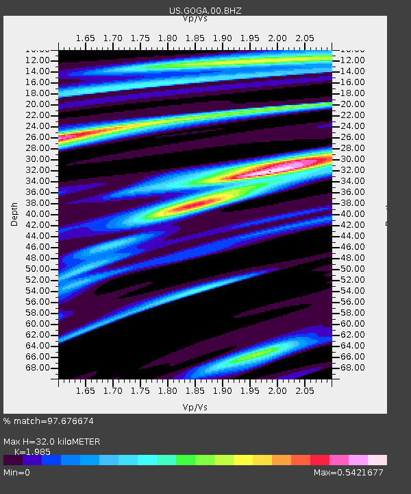
| Estimated Moho Depth: |
32.0 km |
| Estimated Crust Vp/Vs: |
1.99 |
| Assumed Crust Vp: |
6.565 km/s |
| Estimated Crust Vs: |
3.307 km/s |
| Estimated Crust Poisson's Ratio: |
0.33 |
|
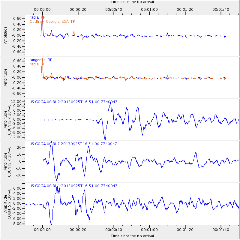
| Radial Match: |
97.676674 % |
| Radial Bump: |
218 |
| Transverse Match: |
91.774345 % |
| Transverse Bump: |
400 |
| SOD ConfigId: |
626651 |
| Insert Time: |
2014-04-18 20:53:19.722 +0000 |
| GWidth: |
2.5 |
| Max Bumps: |
400 |
| Tol: |
0.001 |
|
Signal To Noise
| Channel | StoN | STA | LTA |
| US:GOGA:00:BHZ:20130925T16:51:00.774004Z | 50.81013 | 8.42717E-6 | 1.658561E-7 |
| US:GOGA:00:BH1:20130925T16:51:00.774004Z | 19.506418 | 2.6595953E-6 | 1.3634464E-7 |
| US:GOGA:00:BH2:20130925T16:51:00.774004Z | 33.0172 | 3.898819E-6 | 1.18084486E-7 |
| Arrivals |
| Ps | 5.1 SECOND |
| PpPs | 14 SECOND |
| PsPs/PpSs | 19 SECOND |


