You are here: Home > Network List > US - United States National Seismic Network Stations List
> Station LONY Lake Ozonia, New York, USA > Earthquake Result Viewer
LONY Lake Ozonia, New York, USA - Earthquake Result Viewer
| Earthquake location: |
Near Coast Of Peru |
| Earthquake latitude/longitude: |
-15.8/-74.5 |
| Earthquake time(UTC): |
2013/09/25 (268) 16:42:43 GMT |
| Earthquake Depth: |
40 km |
| Earthquake Magnitude: |
7.1 MWW, 6.8 MI, 7.0 MWB, 7.0 MWC, 7.1 MWW, 7.1 MWC |
| Earthquake Catalog/Contributor: |
NEIC PDE/NEIC COMCAT |
|
| Network: |
US United States National Seismic Network |
| Station: |
LONY Lake Ozonia, New York, USA |
| Lat/Lon: |
44.62 N/74.58 W |
| Elevation: |
440 m |
|
| Distance: |
60.2 deg |
| Az: |
359.941 deg |
| Baz: |
179.92 deg |
| Ray Param: |
0.06163348 |
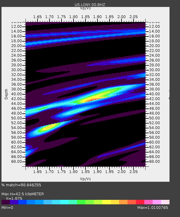
| Estimated Moho Depth: |
42.5 km |
| Estimated Crust Vp/Vs: |
1.88 |
| Assumed Crust Vp: |
6.419 km/s |
| Estimated Crust Vs: |
3.424 km/s |
| Estimated Crust Poisson's Ratio: |
0.30 |
|
| Radial Match: |
98.646255 % |
| Radial Bump: |
173 |
| Transverse Match: |
96.83298 % |
| Transverse Bump: |
293 |
| SOD ConfigId: |
626651 |
| Insert Time: |
2014-04-18 20:53:42.289 +0000 |
| GWidth: |
2.5 |
| Max Bumps: |
400 |
| Tol: |
0.001 |
|
Signal To Noise
| Channel | StoN | STA | LTA |
| US:LONY:00:BHZ:20130925T16:52:16.123979Z | 9.491716 | 2.4232816E-6 | 2.553049E-7 |
| US:LONY:00:BH1:20130925T16:52:16.123979Z | 5.367177 | 1.202366E-6 | 2.2402203E-7 |
| US:LONY:00:BH2:20130925T16:52:16.123979Z | 3.2044084 | 4.1727847E-7 | 1.3022013E-7 |
| Arrivals |
| Ps | 6.1 SECOND |
| PpPs | 18 SECOND |
| PsPs/PpSs | 24 SECOND |


